[성유창의 그랑프리] [ETRI①]ETRI, “2027년 레벨4 자율주행 목표 달성 위해 노력할 것”
기사입력 2022.07.20 10:02
비정형도로·악천후 환경 속 자율주행, 센서 정확도 必
맵데이터·로컬리제이션, 마크 흐릿한 도로서 주행보조
맵데이터·로컬리제이션, 마크 흐릿한 도로서 주행보조
한국전자통신연구원(이하 ETRI)가 레벨4 완전자율주행 기술로 고도화하는 것을 목표로, 현재 정부R&D를 통해 자율주행 기술개발 혁신 사업을 수행하고 있으며 비정형 도로(이면도로)와 악천후 환경 속에서도 문제없이 주행할 수 있도록 연구 중이라고 밝혔다.
민경욱 ETRI 지능로보틱스연구본부 자율주행 지능연구실 실장은 본지와의 인터뷰에서 ETRI의 자율주행 기술과 자율주행 차량 오토비에 대해 설명했다.
민경욱 ETRI 지능로보틱스연구본부 자율주행 지능연구실 실장은 본지와의 인터뷰에서 ETRI의 자율주행 기술과 자율주행 차량 오토비에 대해 설명했다.
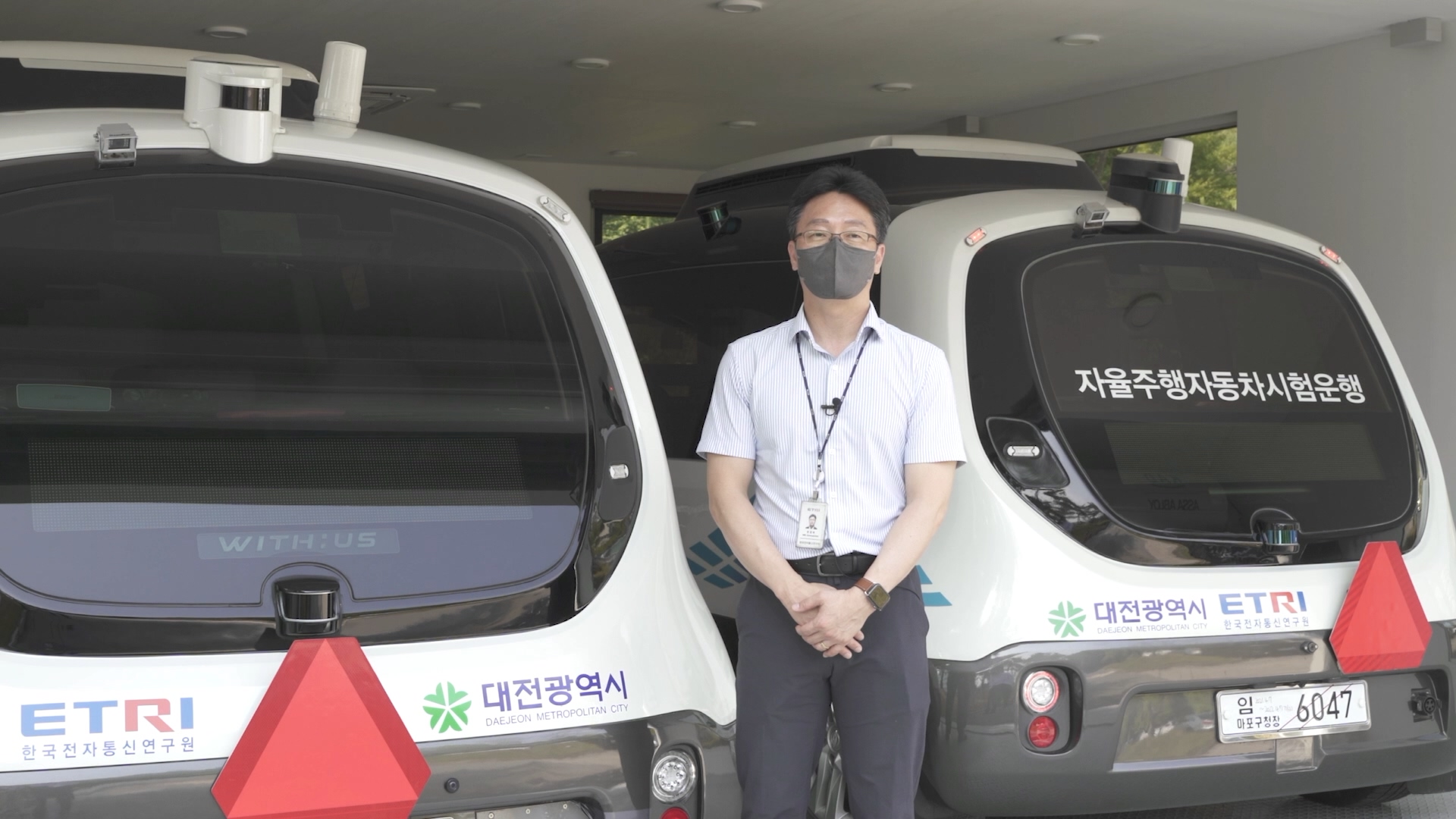
▲민경욱 ETRI 실장
2022년 목표를 묻는 질문에 민 실장은 차선이 명확하지 않은 시골길과 같은 비정형 도로(이면도로)와 악천후 환경 속에서도 문제없이 주행할 수 있도록 연구 중이라고 밝혔다.
비정형 도로와 악천후 환경 속에서의 안전 주행과 국방 등에서의 활용에 있어 센서의 정확도는 필수다.
이를 위해 카메라와 라이다의 융합을 바탕으로 주행환경 및 상황을 인식·예측하는 AI 핵심 기술을 개발했으며, 인지 및 예측 기능을 구현하기 위한 AI 학습·추론 모델을 제공한다.
모델을 학습할 수 있는 데이터를 제공함으로써 다양한 형태로의 변형을 통한 자율주행 소프트웨어 기술 적용이 가능했다.
카메라 영상 데이터와 라이다 데이터로 3D 바운딩 박스에 대한 레이블링을 하면서 어떤 차종인지, 보행자인지를 구별해 대용량의 데이터를 구축하고 이를 학습을 통해서 보다 더 정확하게 주변에 있는 동적 개체를 3D로 검출하는 것이다.
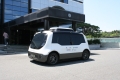
오토비 차량에는 전방에 두 대의 카메라가 설치되어 있고 전·측·후방에는 각각 두 대의 라이다가 설치되어 있다.
라이다 6대를 탑재하여 사각지대를 없애 안정성을 높인 것이 특징 중 하나다. 이는 동적 객체(사람, 차량 등)를 3D 형태로 인공지능으로 인식하는데 활용된다.
카메라 센서는 도로 위에 있는 차선 등의 노면 마크와 신호등을 감지하고, 정지 차량의 후미등이 비상등인지, 후진등인지 등을 인식한다.
횡단보도와 차선이 흐릿해 카메라가 제대로 인식하지 못하는 상황에서는 맵 데이터와 로컬리제이션 기술이 자율주행을 돕는다.
맵 데이터가 구축되어 있으면 우선 차량이 어디에 있는지 알 수 있어 횡단보도가 흐릿하더라도 보행자의 안전을 도모할 수 있다.
로컬리제이션 기술은 카메라와 라이다 정보를 융합하는 기술이다.
카메라 영상의 마크 외에도 라이다에서 인식한 건물 등을 이용해 차의 위치를 보다 정확하게 파악할 수 있도록 하는 기술이다.
ETRI는 인공지능 학습을 위해 5년째 데이터를 지속적으로 구축하고 있다.
수집 차량의 카메라, 라이다, GPS 데이터와 차량의 고정 정보 데이터를 동기를 맞춰 로우데이터를 구축하고, 이 데이터로 레이블링 작업을 통해 학습데이터를 생성한다.
5년동안 약 10만km 이상, 양으로는 200TB 이상, 학습데이터로는 1,400만장 이상의 데이터를 구축해 학습에 활용하고 있다.
기사와 관련된 인터뷰는 기사 위의 영상과 e4ds 유튜브 채널 ‘Electronic's for Design and Software’에서 확인할 수 있다.

관련뉴스
-
ETRI, 비정형도로·악천후 속 안전 주행 연구 박차
한국전자통신연구원(이하 ETRI)가 지난해 ‘오토비’를 선보이며 운전석이 없는 진정한 레벨4 자율주행차 시대를 위한 준비를 마쳤다면, 2022년에는 더 발전된 기술을 선보이기 위한 노력이 이어지고 있다.
2022-05-31 오후 2:40:05by 성유창 기자
-
[인터뷰]민경욱 ETRI 실장, “5년 내 자율주행 선진국과 기술격차 감소”
ETRI는 자율주행 센서의 정확도를 높이기 위해 카메라와 라이다의 융합을 바탕으로 주행환경 및 상황을 인식·예측하는 AI 핵심 기술을 개발했으며, 인지 및 예측 기능을 구현하기 위한 AI 학습·추론 모델을 제공한다.
2022-07-05 오후 3:46:51by 성유창 기자
-
[ETRI②]ETRI, “5G NR 레이턴시 1~3ms 예상”
민경욱 한국전자통신연구원(이하 ETRI) 실장은 5G NR이 개발, 도입되면 레이턴시가 1~3ms로 LTE V2X 대비 약 100배 줄어들어 자율주행의 안전에 있어 큰 도움이 될 것이라고 전했다.
2022-07-20 오전 10:03:22by 성유창 기자

많이 본 뉴스
[열린보도원칙] 당 매체는 독자와 취재원 등 뉴스이용자의 권리 보장을 위해 반론이나 정정보도, 추후보도를 요청할 수 있는 창구를 열어두고 있음을 알려드립니다.
고충처리인 장은성 070-4699-5321 , news@e4ds.com