드론 악용 막는 감지 및 탐지 기술
기사입력 2018.07.19 18:10
일상 깊이 스며든 드론
악용 드론 탐지 필요성 커져키사이트, 드론 탐지 솔루션 제시
2016년 10월, 급진 수니파 무장단체 IS가 날린 드론이 이라크 북부 쿠르드 자치정부 민병대 기지에 폭탄을 떨어트렸다. 이 공격으로 프랑스 특수부대원 2명과 쿠르드족 민병대원 2명이 사망했다. 드론 범죄는 군사 영역에서만 일어나지 않는다. 2017년 8월에는 제주 곽지해수욕장 위로 드론을 띄워 몰카를 찍은 30대 남성이 경찰에 체포되기도 했다.
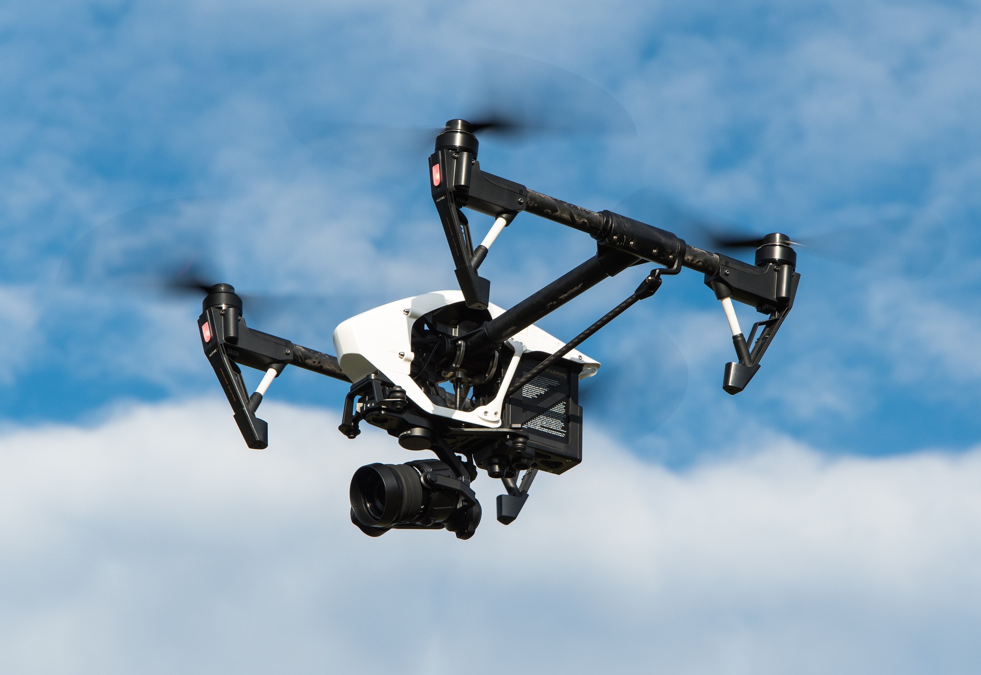
중국 DJI사의 드론 Inspire 1
일상 속으로 파고든 드론
무인 항공기(Unmanned Aerial Vehicle, UAV)를 뜻하는 드론(Drone)이란 용어는 1930년대 영국과 미국에서 대공포 훈련용으로 개발된 무인 항공기를 표적 드론(Target drone)이라 부르면서 최초로 사용됐다. 이후 줄곧 군사용으로만 쓰이던 드론은 2010년대부터 일상 속에도 깊이 스며들었다. 수직 이착륙이 가능한 멀티콥터 형태의 소형 드론이 등장하면서 비전문가도 쉽게 드론을 운용할 수 있게 됐기 때문이다.
드론을 활용한 촬영 영상은 미디어를 통해 쉽게 접할 수 있고, 어린이를 위한 드론 장난감도 시중에 출시된 지 오래다. 드론으로 농부는 농약을 뿌리고 건축기사는 측량을 한다. 미국의 전자상거래 업체 아마존과 국내 1위 택배업체 CJ대한통운은 드론을 활용한 택배를 상용화하기 위해 연구개발을 지속하고 있다. 국내 이동통신 3사는 재난대응 특수임무를 수행하는 드론과 그를 뒷받침하는 5G 인프라 개발에 적극적이다. 2018 평창 동계올림픽 개막식에선 드론 1218대가 밤하늘을 화려하게 수놓으며 전 세계인들의 시선을 사로잡았다.
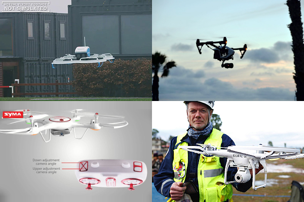
택배, 방송, 놀이, 구조 용도로 쓰이는 드론들
한국항공우주연구원의 조사 결과에 따르면 상용 드론 시장 규모는 2017년 26억 달러 수준에서 2021년 87억 달러 수준까지 커질 것으로 예상된다.
국토부는 2016년 7월, 증가하는 드론 사용에 따라 항공법을 개정했다. 기존 12kg 이상이었던 드론 비행승인 기준을 25kg 이상으로 올린 것이다. 이로써 25kg 이하의 드론은 당국에 신고하지 않고도 날릴 수 있게 되었다. 현재 판매중인 대다수의 상업용 드론은 별도의 허가절차 없이 비행 가능하다. 규제는 앞으로 더욱 완화된다. 올해 9월까지 국토부는 새로운 드론 기준을 마련하기로 했으며 드론 업체의 인증 부담도 적어진다.
범죄에 사용되는 드론
그러나 드론 사용이 증가하는 만큼 드론을 악용하는 사례도 증가하고 있다.
2015년 1월, 미국 백악관으로 드론이 날아들었다. 비행기나 미사일 같은 날아다니는 물체를 감지하기 위해 설치된 백악관의 레이더 시스템은 소형 드론을 미처 감지하지 못했다.
2015년 4월, 일본에서 총리 관저 옥상으로 이른바 ‘세슘 드론’을 날린 40대 남성이 경찰에 자수했다. 남성이 날린 드론은 세슘이 포함된 후쿠시마 모래를 담은 통을 달고 있었는데, 발견될 때까지 무려 13일 동안이나 총리 관저 옥상에 방치되어 있었다.
급진 수니파 무장단체 이슬람 국가(Islamic State, IS)는 2015년 후반기부터 민수용 드론을 이용한 폭탄 투하 공격을 감행했다. 2016년 10월, IS가 이라크 북부 쿠르드 자치정부 민병대 기지에 드론으로 떨어트린 폭탄에 의해 프랑스 특수부대원 2명과 쿠르드족 민병대원 2명이 사망하는 사건이 발생했다.
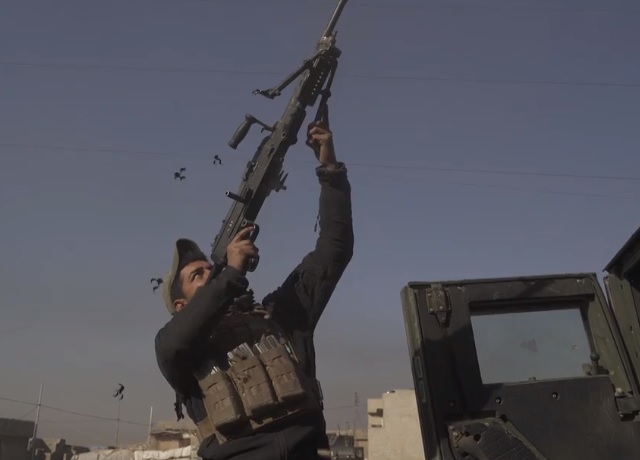
드론을 향해 사격하는 이라크 정부군 병사
2017년 4월, 뉴욕 타임스의 벤 솔로몬 기자는 이라크 정부군의 모술 탈환작전 취재에 나섰다가 IS가 날린 드론과 마주했다. 그 드론은 중국 DJI사에서 민수용으로 판매하는 ‘팬텀’이었고 이라크 정부군의 난사에도 격추되지 않고 폭탄을 투하했다. 이라크 정부군 진영으로 떨어진 폭탄에 군인 및 취재진 등이 큰 부상을 당했다.
지난 2018년 7월 2일에는 예멘 반군이 언론을 통해 아랍에미리트(UAE) 병력을 향한 드론 활용 폭탄 투하 영상을 공개하기도 했다.
드론은 이미 전세계 교정 당국들의 골칫거리다. 드론을 이용한 교도소 내 허가되지 물건 반입이 날로 증가하고 있기 때문이다.
국내에서도 드론을 이용한 몰카 범죄가 기승을 부리고 있다. 2017년 8월에는 제주 곽지해수욕장 위로 드론을 띄워 몰카를 찍은 30대 남성이 경찰에 체포되기도 했다.
드론 대응 방법
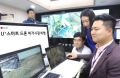
지난 7월 19일 드론 감지 기술에 대한 세미나를 진행한 키사이트의 김규일 대리는 드론 대응 방법을 크게 3단계로 나누었다. 첫 번째는 드론 감지(Detection)로, 드론이 있다는 걸 알아내는 단계다. 두 번째는 드론 탐지(Location)로, 드론이 어디 있는 지 찾아내는 단계다. 세 번째는 드론 무력화(Mitigation)로, 드론을 동작 불능 상태로 만드는 것이다. 키사이트의 솔루션을 중심으로 세 단계 중 앞선 두 단계인 드론 감지와 탐지 방법에 대해 소개한다.
드론 신호 수집 및 분석 하드웨어와 소프트웨어
드론 감지는 드론에서 나오는 신호를 잡아내야 진행할 수 있다. 이를 위해 신호를 받기 위한 수신기나 안테나 같은 하드웨어와, 하드웨어가 받은 신호를 분석하는 소프트웨어가 필요하다.
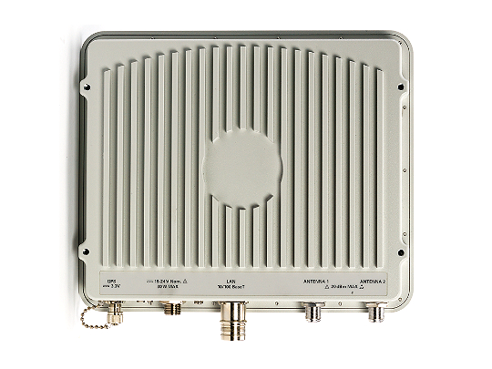
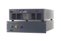
키사이트의 N6841A
키사이트의 N6841A는 실내외에서 사용 가능한 RF(Radio Frequency) 수신기다. N6841A가 받은 신호는 PC에 설치된 소프트웨어로 분석할 수 있다. 9월에 출시될 N6850A 전방향 광대역 안테나는 N type 케이블을 이용해 N6841A와 연결할 수 있어 신호 분석 범위를 넓힐 수 있다.
SPOT(Sensor Placement and Optimization Tool)은 RF 신호 전파를 볼 때 사용하는 소프트웨어다. 수신기가 설치되어 있는 위치를 기준으로 신호 감지 범위를 알려준다.
N6820ES Signal Surveyor 4D는 무선 통신환경에서 여러 정보들을 찾아내고 수집하기 위한 고속 신호 모니터링 소프트웨어다. 여러 개의 안테나와 수신기로 들어오는 신호들을 동시에 모니터링 하는 것이 가능하다. 여러 기능들을 포함하고 있어 상황에 따라 사용자가 유연하게 응용할 수 있다.
N6854A RF Geolocation Server Software는 RF 신호가 어디서 나오고 있는지 실제 위치를 지도 상에서 확인할 수 있는 소프트웨어다. 서로 다른 위치에 설치되어 있는 여러 개의 수신기로 TDOA 방식이나 RSS 방식, 또는 둘 다 사용하는 하이브리드 방식으로 위치를 찾아낼 수 있다.
TDOA(Time difference of Arrival, 도착시간차)는 신호원으로부터 발생한 신호가 각 수신기에 도달하는 시간차를 의미한다. RSS(Received signal strength)는 수신된 신호의 세기다. 설치된 여러 개의 수신기는 GPS를 통해 시간 싱크가 다 맞춰져 있으므로, 신호가 들어온 시간과 들어온 신호의 세기로 신호원의 위치를 파악할 수 있다.
TDOA 방식 활용으로 드론 위치 파악
TDOA 방식의 핵심은 모르는 곳에서 발생한 신호가 두 개 이상의 위치에 설치된 수신기에 도착하는 시간을 정확하게 파악하는 것이다. 신호원이 어디에 있고 언제 신호를 보냈는지 모르기 때문에 도착시간차는 매우 중요하다. 수신기의 위치와 신호원과 수신기 간의 거리를 알고 있음으로 신호원의 위치는 삼각법으로 계산이 될 수가 있다.
최소 두개 이상의 수신기가 꼭 필요한데, 만약 두 개의 수신기가 있다면 신호원으로부터 수신된 신호가 어디 있는지 예측을 하기위해서 각각의 수신기로부터 쌍곡선의 형태로 라인을 그릴 수가 있다.
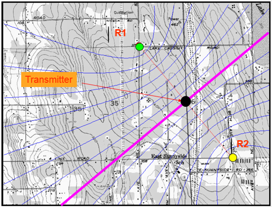
검은 점이 드론이고 R1과 R2가 수신기다.
드론과 양쪽 수신기와의 거리가 동일하다면, 양 쪽 수신기에서는 동일한 시간에 드론 신호가 수신될 것이다. 이 때 TDOA, 즉 시간차는 0이 된다. 그러나 드론 신호의 절대 시간을 알 수 없기 때문에 정확한 위치를 알아낼 방법이 없다. 이처럼 TDOA가 0이라고 하면, 드론은 두 수신기로부터 거리가 같은 어느 위치, 즉 그림에 나타난 분홍색 선 위 어디에도 있을 수 있다.
만약 드론으로부터의 거리가 양쪽 수신기와 다르다면 TDOA는 0이 아니게 된다. 그러면 그림 상에 그려져 있는 쌍곡선 중 어느 쌍곡선 위 어디에도 있을 수 있다. 따라서 2개의 수신기만으로 드론이 어디에 있는지 정확히 파악하는 건 쉽지 않다.
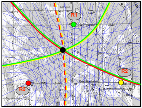
한 개의 수신기를 더 추가할 경우, 수신기의 조합은 3개(R1-R2, R1-R3, R2-R3)가 된다. 이 경우 두 개의 수신기를 사용했을 때보다 쌍곡선이 많이 생기므로 이론적으로는 한 점에서 만나게 된다. 만약 여기에 네 번째 수신기가 추가된다면 수신기의 조합은 6개로 늘어나 더욱 효과적이고 정확하게 드론의 위치를 파악할 수 있다.
드론 최종 위치 확정 위해선 휴대용 측정 장비 필수
앞서 설명한 하드웨어와 소프트웨어로 드론의 대략적인 위치를 파악했다면 현장에 나가 휴대용 장비를 활용해 정확한 위치를 확정할 수 있다.
Fieldfox는 키사이트의 휴대용 장비다. 크기는 A4용지 정도에 무게는3.2kg이라 휴대에 용이하다. 50GHz 주파수까지 측정 가능하다. 최근에는 실시간 신호분석 기능(Real-Time Spectrum Analyzers, RTSA)이 옵션이 추가되어 빠른 속도로 생기고 없어지는 신호 측정이 가능하다. Fieldfox가 지원하는 RTSA 스펙은 12us의 100% POI다. 12us 펄스 폭 신호를 100% 감지할 수 있다는 의미다.
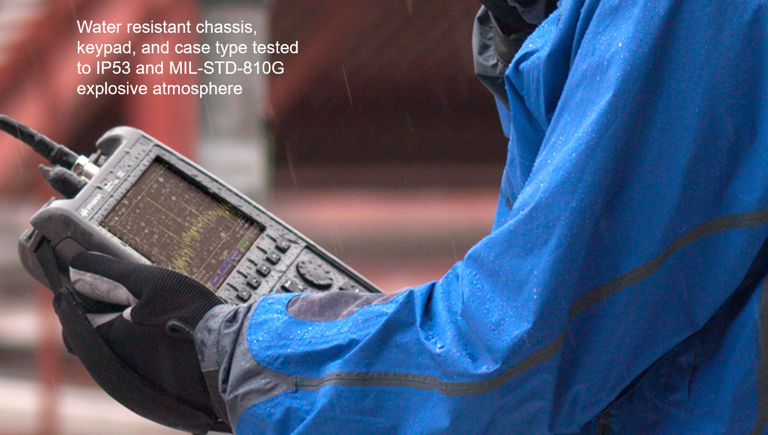
키사이트의 Fieldfox는 휴대성으로 사용자의 기동성을 높였다.
Fieldfox의 가장 큰 장점은 한 장비에 여러가지 계측기능이 모두 들어있다는 것이다. 옵션에 따라 Network analyzer, Power meter, Vector voltmeter, TDR(Time-domain reflectometer) 측정 기능까지 제공한다. 드론 감지 뿐만 아니라 야외, 혹은 일반 벤치탑(Bench top) 장비를 갖고 가기 힘든 상황에서 편리하다. Fieldfox는 IP53 규격을 만족하므로 어느 정도 방수 기능을 제공한다. 또 미 육군 MIL-STD-810 규격을 만족하므로 극한상황에서의 사용성도 보장된다.
드론 고유 주파수 구별해내는 TIP 3가지
드론은 ISM(Industry-Sience-Medical, 산업-과학-의료) 주파수 대역을 사용한다. 이 주파수 대역은 전세계에서 공동으로 사용하는 대역으로, 별도의 주파수 사용료를 내지 않는다. 또 공동 사용을 전제로 하기 때문에 상호간섭을 어느 정도 용인하며, 서로 간 간섭을 최소화하기 위해 소출력을 기본으로 한다.
주로 사용되는 ISM 대역은 400MHz 대역, 2.4GHz 대역, 5.8GHz 대역이다. 이 대역을 사용하는 각종 장비 출력 규격은 용도 별로 제한되어 있으며 나라마다 다르다. 와이파이나 블루투스가 이 대역을 사용한다. 드론에서 나오는 신호를 감지하기 위해선 ISM 대역에서 나오는 많은 신호들 중 어느 신호가 드론에서 나오는 신호인지 구별해야 한다.
방법은 세가지다.
첫 번째는 특정 대역을 지정하는 것이다. 상용화 된 드론이 사용하는 주파수 범위는 서너 대역 정도로 한정되어 있다. 따라서 광대역으로 신호를 분석하는 것이 아니라 특정 주파수 범위를 협대역 몇 개로 지정해서 볼 때 신호를 발견할 확률이 높아진다. N6820ES Signal Surveyor 4D가 관련 기능을 제공한다.
두 번째는 소프트웨어 상에서 스레숄드(Threshold)를 지정하는 것이다. 봐야하는 신호는 드론 신호 뿐이므로, 에너지 히스토리를 레코딩해서 항상 존재하는 신호를 리미트 라인 처리한다. 그러면 라인 아래 신호들이 전부 필터링되어 위로 올라오는 신호만 볼 수 있다. 반대로 찾고자 하는 신호의 대략적인 형태나 크기를 소프트웨어 상에 넣어 유사한 신호가 나올 때마다 사용자에게 알람을 주는 스펙트럴 셰이프 디텍터(Spectral shape detection) 기능을 사용할 수도 있다.
세 번째는 신호를 포착하는 범위에 제한을 두는 것이다. 지도 상 어느 범위를 지정하면, 그 범위 안에 있는 영역에서 나오는 신호만 잡아낼 수 있다.
어느 지점을 중심으로 반지름을 입력해서 원 형태로 범위를 지정할 수 있으며, 위도 경도를 지정해서 박스 형태로 지역을 지정하는 것도 방법이다. 선택한 범위 외의 신호는 소프트웨어에서 자동으로 필터링 된다.
양날의 칼, 드론 잡기
드론은 소형화가 가능하고 기동성이 좋아 어디든 자유자재로 드나들 수 있다. 따라서 드론의 활용 가능성은 무궁무진하다. 그러나 이런 드론의 유용성은 쓰임에 따라 위험성으로 바뀐다. 드론은 사용자의 긍정적, 혹은 부정적 의도에 따라 대중에게 좋은 영향을 끼칠 수도 있고 나쁜 영향을 끼칠 수도 있다. 사람을 구할 수 있지만 죽일 수도 있다. 부정적인 의도로 사용되는 드론을 막기 위한 드론 감지 및 탐지 기술의 필요성이 날로 커지는 이유다.
드론 감지 및 탐지 기술에는 신호를 수신하는 하드웨어와 수신한 신호를 분석하는 소프트웨어가 필요하다. 그리고 드론의 위치를 특정하기 위해 휴대용 측정 장비를 보조적으로 사용해야 한다. 그러기 위해서는 ISM 대역에서 드론 고유의 주파수를 포착할 수 있어야 한다. 방법은 3가지다. 특정 주파수 대역을 지정하는 것, 소프트웨어 상에서 찾고자 하는 주파수 외의 다른 주파수 신호를 제외하는 것, 그리고 신호 분석 영역을 특정 지역으로 제한하는 것이다.
이수민 기자
관련뉴스
-
고성, 보은, 영월에 드론 전용 비행시험장 생긴다
국토교통부는 민간의 드론 비행시험을 지원하기 위해 시험공간, 전문시설 등을 종합적으로 제공하는 드론 전용 비행시험장 공사를 착수한다. 그간 국내 드론산업 육성 및 안전기준 연구 등을 위해 드론 시범사업 전용공역(7곳)을 확보하고 실증 시범사업을 추진 중(‘16.2.~)이나, 국가 종합비행시험장이 구축되는 고흥지역 외에는 드론의 다양한 비행시험 및 시범운영 등을 위한 전문 시설이 부족했다. 이에, 국토부는 드론의 연구‧개발 및 상용화 과정에서 시제기의 비행 안전성, 운영성능 등을 시험‧검증하기 위해 안전‧통제‧시험‧정비 시설이 구축되는 드론 전용 비행시험장 조성을 추진해 왔다.
2018-05-15 오후 5:39:40by 김지혜 기자
-
LG유플러스, 한화정밀기계와 국내 최초 드론 비가시권 비행 승인 받아
LG유플러스는 한화정밀기계와 함께 국내 처음으로 드론 비가시권 특별비행 자격을 획득했다고 밝혔다. 앞서 LG유플러스와 한화정밀기계는 드론 비가시권 특별비행 승인을 위해 항공안전법의 ‘무인비행장치 특별비행을 위한 승인절차에 관한 기준’에 따라 드론 비행의 목적, 방식, 비행경로, 고도 등을 포함하는 비행계획서를 제출했다.
2018-05-24 오전 11:30:39by 김지혜 기자
-
키사이트, e-모빌리티 테스트 및 측정 솔루션 출시
새로운 솔루션, 하이브리드, 전기차 및 관련 에너지 저장 장치에 사용되는 셀과 배터리 기술, 전동 파워트레인 컴퍼넌트 및 서브 시스템의 발전 가능성을 높여
2018-06-14 오전 6:38:14by 명세환 기자

많이 본 뉴스
[열린보도원칙] 당 매체는 독자와 취재원 등 뉴스이용자의 권리 보장을 위해 반론이나 정정보도, 추후보도를 요청할 수 있는 창구를 열어두고 있음을 알려드립니다.
고충처리인 장은성 070-4699-5321 , news@e4ds.com