점군 지도 비교 갱신 알고리즘을 보유하고, 기존에 구축된 점군과 비교하여 달라진 부분만 추출이 가능한 기술을 가진 모빌테크를 '2022 e4ds 오토모비트 테크 콘서트'에 초대하고 연사로 참여하는 유형곤 모빌테크 본부장과 이야기를 나눴다.
▲ Yoo Hyeong-gon, Head of Mobiltech Headquarters
Patent for automatic point cloud map using LiDAR, self-developed mapping and deep learning algorithm
On the 28th, 'Realistic Smart City Implementation 3D Spatial Information Update and Utilization Technology' announced [Editor's Note] The precision road map is used as basic data for autonomous vehicle location recognition and judgment. Accordingly, it is necessary to build a high-quality precision road map and provide the latest data through rapid updates. Mobiltech possesses road facility and object detection technology, which allows for faster updates of the precision map, which was previously updated annually. We invited Mobiltech, which has a point cloud map comparison update algorithm and a technology that can extract only the parts that have changed compared to the existing point cloud, to the '
2022 e4ds Automotive Tech Concert ' and spoke with Yoo Hyeong-gon, head of Mobiltech headquarters, who will be participating as a speaker on October 28.
■ Introduction to Mobiltech and what research and development is currently being done Mobiltech is an AI-based 3D spatial information startup. We are developing a 3D space scanner that replicates space as it is, and supplying realistic 3D space information, hardware, and software solutions for smart cities.
We have supplied 3D data platforms for autonomous vehicles and delivery robot services to over 30 locations at home and abroad, including Silicon Valley, and are currently expanding our business areas to include ▲realistic digital twin services using 3D precision maps and ▲establishing extended reality (XR) and metaverse services.
■ Please introduce Mobiltech’s technology and advantages. Mobiltech has the technology of XL-Replica based on mapping and deep learning algorithms.
Based on this, we developed our own MMS system and have used it to provide precision maps to approximately 30 domestic locations, including large domestic corporations and research institutes.
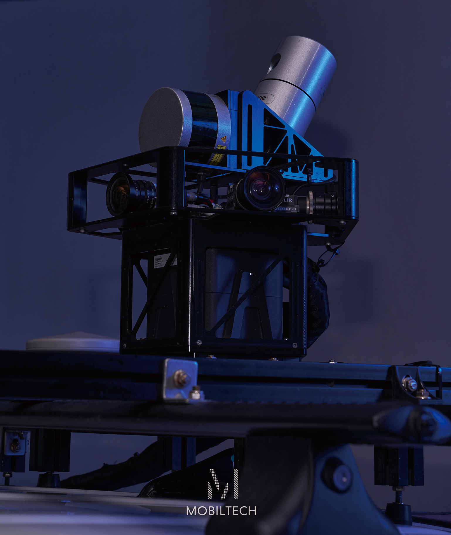
Mobiltech's XL-Replica is the only domestically developed multi-channel MMS equipment that passed the National Geographic Information Institute's test survey this year.
▲ Mobiltech MMS equipment XL-replica (Photo courtesy of Mobiltech)
Unlike the foreign equipment mainly used by existing surveying companies, Mobiltech uses multi-channel lidar to enable scanning at a much faster speed and can rapidly shorten the data acquisition time.
In addition, it has the advantage of providing a reasonable price that is about half that of expensive foreign equipment and stable data.
Additionally, Mobiltech holds a patent for automatic point cloud map updates using LiDAR coordinates, and its self-developed mapping and deep learning algorithms are embedded within the XL-Replica.
This can drastically reduce post-processing costs and time by automatically performing post-processing tasks such as removing noise generated by cars during the mapping process and automatically extracting roads and signs.
In addition, Mobiltech also provides a convergence sensor system and data construction system, which are the core of high-precision map production developed in-house, and a 3D map service based on these.
We are automatically classifying and analyzing a large amount of data based on AI to update facility (POI) information on various objects in cities and on roads on a daily, weekly, and monthly basis.
Existing map and spatial information services take 3 to 6 months to update, and changes in roads are not immediately reflected.
Mobiltech uses camera/lidar data and AI to automatically detect and update spatial change points, and provides the most up-to-date data to secure the competitiveness of map data.
Furthermore, it provides realistic 3D modeling based on Unreal using lidar scan and image results, providing more accurate and identical spatial information to the actual environment.
■ Please explain the ‘3D spatial information update and utilization technology for implementing a realistic smart city’ that will be presented at this Automotive Tech Concert.
At the '2022 e4ds Automotive Tech Concert', we would like to first introduce 'Replica City', which can provide 3D spatial information update and utilization technology as a single service.
Mobiltech's 'Replica' City is a 3D city data solution that provides up-to-date data on the city that changes every day.
Self-made equipment is mounted on a vehicle to scan the city every day, and the city object information (POI) obtained during this time is built into a database every day.
Based on these data, a realistic 3D model is created through automatic modeling post-processing.
Mobiltech is solving the problem of data collection and processing, which takes up a lot of time and money in map production, through AI automation, and is developing a technology to detect changes in spatial information and automatically update it by learning AI artificial intelligence based on the acquired data, thereby updating 3D spatial information every day.
Replica City can be used as the core infrastructure of a customized metaverse desired by each organization (B2B, B2G), and can provide POI (Point of Interest) big data on various city objects that were not provided in existing maps.
Furthermore, mobile tech can be expanded beyond high-precision maps to autonomous driving and digital twins, and into various services such as virtual production, simulation, and UAM.
■ What technologies or topics are currently hot topics in the industry?
Since high-precision road maps are used as basic data for autonomous vehicles' location recognition and judgment, in order to realize safe autonomous driving, it is necessary to build high-quality high-precision road maps and provide the latest data through rapid updates.
The key to building a high-precision road map is the MMS (Mobile Mapping System) equipment that acquires road data.
MMS is a mobile 3D spatial information system that combines a camera, lidar, GPS, and driving distance sensor (DMI).
It is installed in a vehicle or other moving object and has a wide range ofIt is possible to build precise location and visual information of terrain features around the road in centimeter units.
Amidst this, there is a growing trend of observation that it is difficult for domestic surveying companies to quickly build 3D map data using overseas MMS equipment.
This is because it is burdensome for surveying companies to additionally introduce expensive MMS equipment, and there is a lack of software compatibility and data lightweight technology for processing acquired data.
Currently, companies that build high-precision road maps are importing foreign equipment worth more than 1 billion won per unit and using them in their business, but they are only focusing on building data, and thus lack the ability to invest in technology development for quality verification and updates of the built data.
In addition, to update with precision, not only equipment but also algorithm development must be supported.
To solve this problem, Mobiltech has a point cloud map comparison update algorithm that can extract only the parts that have changed compared to the previously constructed point cloud.
In addition, we hold a patent related to automatic point cloud map updates using LiDAR coordinates, and we plan to verify our self-developed change detection algorithm in this National Geographic Information Institute precision road map renewal project.
Due to the nature of map services, maintaining ‘up-to-dateness’ is essential, but there is a limit to ‘periodic updates’, and in the case of domestic and international precision road map services, there is no service that conducts precise analysis and periodic updates of information on surrounding facilities in addition to roads.
Mobiltech possesses road facility and object detection technology, and by applying this, it is possible to detect and visualize approximately 100 types of data, including lanes, road markings, road facilities, and buildings.
It can be used in various industrial fields and isIt is expected that the high-precision map, which was updated on a per-minute basis, will be able to be updated more quickly.
■ Please tell us about the industry outlook and the direction (strategy) that Mobiltech will take.
Mobiltech is expanding its presence in the established map industry and establishing a standard model for how to build domestic digital twins.
Furthermore, we are implementing realistic 3D cities to provide differentiated services from existing precision map companies, and we plan to expand this realistic data into services for not only autonomous vehicles but also new markets such as △virtual production, △content creation, and △UAM.
■ Please say a word to your readers.
Precision road maps play a fundamental role in various fields such as autonomous driving, road, traffic, facility management, VR/AR, and metaverse.
We plan to continue to contribute to the development of the spatial information industry by utilizing the technological capabilities possessed by Mobiltech.
I think this event would be a good opportunity to have an in-depth discussion with readers about the usability of precision maps.