아이나비시스템즈가 미래 지도 시장의 핵심인 자율주행 분야에서 정밀지도 구축과 자율주행 시대가 요구하는 기술들을 연구 및 개발하고 있다며 진행 중인 연구 과제 등 다양한 정보를 공유했다.
e4ds는 지난 21일 2022 e4ds 오토모티브 테크 콘서트에서 ‘지정구역 기반 Point-to-Point 이동을 위한 하이브리드 지도’을 주제로 아이나비시스템즈의 박진근 이사를 초청해 웨비나를 개최했다.
‘아이나비’ 내비게이션 서비스로 많이 알려진 아이나비시스템즈는 택시, 물류, 배달 등 다양한 모빌리티 산업에 지도를 공급하고 있는 ‘지도 플랫폼’ 전문 기업으로 자리잡고 있다.
박 이사는 “‘지도’ 라는 재료로 플랫폼 서비스를 하기 위해서는 다양한 기술들이 필요하다”며 “아이나비시스템즈는 현장조사, 데이터 구축, 경로탐색 등의 코어 엔진들과 서비스 개발 기술을 보유하고 있다”고 소개했다.
현재 이 기업은 자율주행 관련해 산업통상자원부에서 주관하는 자율주행 정부과제 두 가지를 진행하고 있으며 자율주행시스템(ADS)을 개발하는 여러 자율주행 플레이어와 지도 공급과 자율주행 기술 협력을 위해 노력하고 있다.
발표 주제인 지정구역기반 P2P 자율주행은 2021년 산업통상자원부 정부 과제 중 ‘지정구역 기반 P2P 이동 Lv4 승합차급 자율주행 차량플랫폼 기술개발’ 과제에서 연구하고 있는 부분으로 아이나비시스템즈는 지도 구축과 길 찾기 기술로 자율주행차를 위한 경로를 생성하고, 자율주행차가 추종하는 궤적 정보를 생성하는 기술을 연구하고 있다.
P2P 자율주행은 내비게이션 경로 탐색 기술을 활용해 자율차의 경로와 궤적(Trajectory)를 생성하는 기술을 확대 적용한 콘셉트로 자율차의 자유로운 이동을 보장하기 위해 필요한 기술로 꼽힌다.
아이나비시스템즈는 이 기술의 일환으로 하이브리드맵을 연구 및 개발하고 있다.
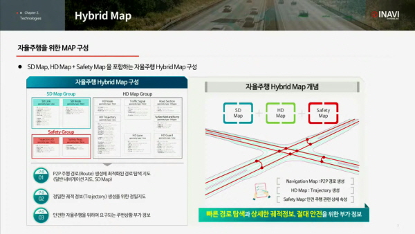 ▲ 아이나비시스템즈 하이브리드맵 구성
하이브리드 맵은 △P2P 경로 생성에 최적화된 경로 탐색지도인 SD Map △정밀한 궤적 정보 생성을 위한 HD Map △안전한 자율주행을 위해 요구되는 주변상황(GPS 음역지역 등)에 대한 부가 정보인 Safety Map으로 구성된다.
궤적을 생성하려면 SD와 HD Map이 연결성을 가져야 하기에 SD Map의 방향성을 가진 Node2Node와 HD Map의 링크 그룹핑 정보를 하나의 연결정보로 구성을 한다.
아이나비시스템즈가 현재 연구 및 개발 중인 기술은 승합차급 자율주행 경로 생성이기 때문에 승합차의 제원을 고려해야 하고, 안전한 경로 및 자율차 주행 불가 도로 회피 알고리즘도 설계해야 한다.
위와 같은 이유로 급격한 회전 반경과 좁은 유턴 도로, 이면도로, 좌회전 직후 목적지인 경우, 어린이 보호구역 등은 회피하도록 구축된다.
박 이사는 “자율주행의 성공 요인은 사람의 불안감 해소”라며 “아이나비시스템즈는 불안감 해소를 위해 개발 단계에서 회피 사항들을 최대한 고려하고 있다”고 전했다.
이어 2027년에 레벨4 자율주행이 상용화된다면 궁극적으로 사람이 운전하는 것과 같은 경로를 제공하는 방향으로 고도화해야 한다고 덧붙였다.
궤적(Trajectory)는 자율차가 추종하는 궤적 정보를 의미한다.
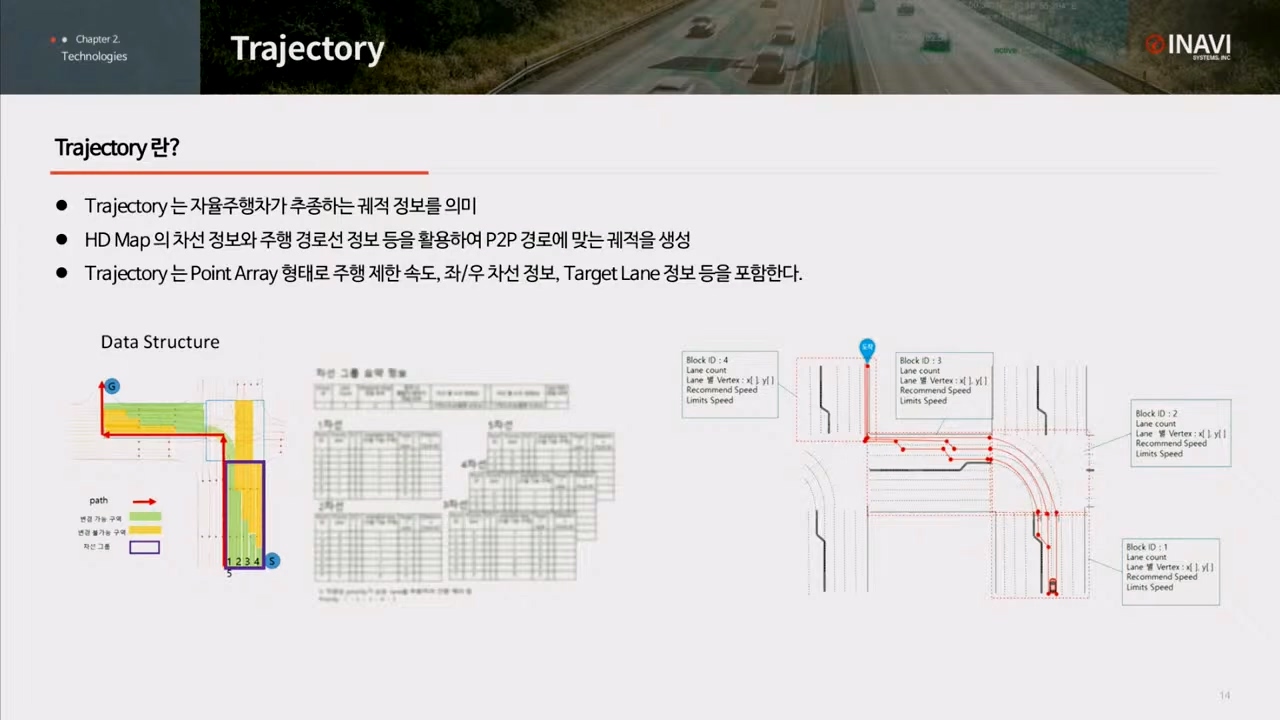 ▲ Trajectory 정보
HD Map의 차선 정보와 주행 경로선 정보 등을 활용해 P2P 경로에 맞는 궤적을 생성하며, Trajectory는 Point Array 형태로 주행 제한 속도, 좌·우 차선 정보, Target Lane 정보 등을 포함한다.
Trajectory의 첫 번째 핵심은 지도 표현에서 가장 단순한 Point로 구성되며 다양한 속성 정보로 구성된다는 점이다.
자율차에 친절하게 데이터를 제공하겠다는 아이나비시스템즈의 개발 목표와 맞닿아 있다.
HD Map은 본래 복잡한 형상과 다양한 속성으로 구성되어 차량이 연산할 때 복잡한 알고리즘이 필요한 반면, Trajectory라는 경로에 한해 압축된 자율주행 정보로 단순한 point 형태로 제공한다.
두 번째는 주행 가능 차선의 우선 순위 결정을 위한 Lane Score를 부여하는 것이다.
좌회전을 할 때는 자율차가 가급적 1차선으로 주행할 수 있도록 유도하고, 우회전은 맨 오른쪽 차선으로 Lane Score를 부여한다.
셋 째는 차선 변경으로, 실제 차량 주행 궤적을 통해 회전을 위한 최적의 차선 변경 지점을 생성하는 것이다.
최초 회전 후에 빠르게 차선을 유도하도록 로직을 설계했으나, 다양한 도로 상황과 조건에 따라 차량 변경 시점이 상이한 것을 파악하고, 사람의 차선 변경 패턴을 분석하고 이를 바탕으로 고도화하려 개발 중이다
최적의 차선 변경 시점을 생성하려는 경우 Trajectory를 효과적으로 활용할 수 있는 방안에 대한 시청자의 질문에 박진근 이사는 “로직만으로는 모든 도로 상황을 분석하기는 어렵다고 판단했다”며 “실제 사용자와 테스터들이 주행하는 궤적을 보며 도로와 차선 변경 패턴을 매칭해 고도화하려 준비하고 있다”고 전했다.
이어 내비게이션 기능 외에 도로의 상태(비포장, 자갈길) 등을 나타내는 기능 개발이 있는지에 대한 시청자의 질문에는“기본적으로 네트워크 데이터 속성에 위와 같은 것들을 구성하는 부분이 있다”며 “포트 홀과 같은 부분은 자율주행에 위험 요소가 될 수 있어 Safety Map의 레이어로 위험 요소를 구성해 자율차에 알려주는 역할을 하고 있다”고 답했다.