



Velodyne-YellowScan Leading Drone Survey Market for Highway Expansion Projects
 Published2019.01.28 17:51
YellowScan Surveyor Easily Adaptable to Any Drone
Delivers 100 Data Points per M2 with Accuracy Below 5cm
On the 23rd, Velodyne Lidar announced that YellowScan's YellowScan Surveyor has utilized Velodyne's sensor technology to collect precise mapping data for an infrastructure construction project on one of the busiest roads in Central Europe.
The YellowScan Surveyor, an unmanned aerial vehicle (UAV) surveying system, collects precise and detailed topographic data through efficient methods, delivering superior results compared to time-intensive manual surveying work of the past.
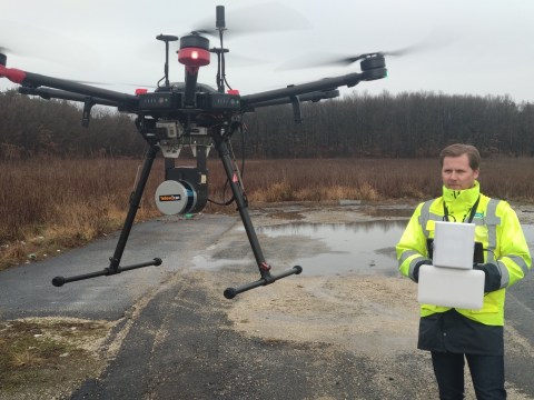
Ventus-Tech generates accurate mapping data using the YellowScan Surveyor equipped with Velodyne Lidar's Puck
This project collecting data from a 47-kilometer section of the M1 highway (E60, E65, E75) in northwestern Hungary was conducted by Ventus-Tech using the YellowScan Surveyor.
Data collected by launching unmanned aerial vehicles 88 times over one month enabled engineers to design plans to expand the highway from two lanes in each direction (2+2) to three lanes in each direction (3+3).
The YellowScan Surveyor is equipped with Velodyne Lidar's "Puck," a compact, multifunctional sensor that accurately measures and analyzes all terrain features and provides high-resolution 360-degree surrounding view imagery.
Pierre d'Hauteville, CEO of YellowScan, stated: "The YellowScan Surveyor is a true turnkey solution for advanced applications like highways, preventing organizations from conducting costly and risky manual surveying. Using Velodyne's lidar technology, we can provide accurate and dense data and generate georeferenced point cloud data in real time," he said.
.jpg)
The YellowScan Surveyor provides 3D data that accurately depicts the landscape
In this project, the YellowScan Surveyor equipped with Velodyne's Puck sensor delivered 100 data points per square meter with accuracy below 5 centimeters. Detailed accuracy is particularly important when redesigning existing roads, as existing infrastructure, drainage networks, and vegetation must be considered. The project is currently in the design, planning, and approval phase, with final design approval expected by mid-2019 and construction completion planned by 2022.
Mike Jellen, President and Chief Communications Officer (CCO) of Velodyne Lidar, stated: "Industry-leading companies rely on the rich data captured by Velodyne's computing to provide surveying systems with minimized complexity. YellowScan's robust and fully integrated system is designed to meet the demanding requirements of complex surveying and topographic applications, and the YellowScan Surveyor easily adapts to any drone, generating data whenever and wherever customers need it," he said.
Balint Vanek, Chief Technology Officer (CTO) of Ventus-Tech, stated: "The YellowScan Surveyor enables us to conduct surveying quickly and efficiently while minimizing disruption to road traffic, supplying detailed 3D data that accurately depicts the terrain. Without YellowScan's support, we would not have been able to undertake such a complex large-scale project," he said.
Comments
Related news
ams Launches TDC for LiDAR and Medical Imaging Applications
ams has launched the AS6501, a new two-channel TDC product. The AS6501 delivers high-speed scanning and high-precision characteristics in single-beam optical distance measurement equipment and medical imaging systems.
2018.10.03by 이수민 기자

Velodyne Lidar Presents the Future of Lidar at IDTechEX
Velodyne Lidar will host a conference on the future of lidar technology at IDTechEX, taking place November 14-15 at the Santa Clara Convention Center in California, USA. The event is expected to attract over 3,500 participants from diverse academic backgrounds, including industry executives and manufacturers. The conference will be led by Dr. Anand Gopalan, Chief Technology Officer of Velodyne Lidar, and Dr. Stephen Nestinger, Director of Mechanical Engineering.
2018.11.11by 이수민 기자
Velodyne Lidar Receives Nikon Optical Technology Integration
Velodyne Lidar has attracted a $25 million investment from Nikon Corporation. The two companies have also begun discussions on multi-faceted business partnerships. Under the goal of integrating Nikon's optical and precision technologies with Velodyne's sensor technology, the companies are seeking comprehensive business partnerships including technology development and manufacturing collaboration.
2018.12.26by 이수민 기자
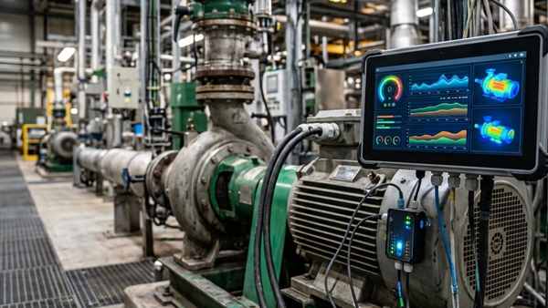
[Technical Contribution] Mouser: "AI Agents Help Accelerate and Standardize Industrial Field Maintenance Operations"
Abhishek Jadhav from Mouser Electronics discusses how to leverage agentic AI for predictive maintenance in industrial automation.
2026.10.23by 편집부
Schneider Electric Unveils Modular Power Solution for AI Data Centers
Schneider Electric has launched prefabricated power modules and power skids for AI data centers, jointly developed with NVIDIA. Based on the GB300 NVL72 reference design, the solution applies standardized design and factory pre-fabrication methods to build power infrastructure in as little as 6 months. Galaxy VXL UPS technology is integrated, with capacity options ranging from 2MW to 2.5MW.
2026.10.23by 배종인 기자











