


Improving the basic spatial information system to realize a smart country
 Published2017.12.21 09:05
The Ministry of Land, Infrastructure and Transport has finalized the ‘Spatial Information Research and Development Innovation Roadmap’ and the ‘Basic Spatial Information System Improvement Plan.’
Spatial information is gaining importance as a foundation for supporting the development of new industries such as self-driving cars, drones, and smart cities in the era of the 4th industrial revolution. However, domestic spatial information technology is only 74.5% of the world's best, and the technology gap is about 3 years behind.
Research and development to overcome this has also shown limitations in that it does not properly reflect future prospects and technological demands, and is promoted by focusing on areas where research and development is possible in terms of fragmentary demand response.
In addition, inconveniences in use due to the lack of systematic quality management of basic spatial information, which serves as the basic framework for integrating/utilizing spatial information such as terrain, roads, rivers, and buildings, have been continuously raised.
Accordingly, the Ministry of Land, Infrastructure and Transport has been working to establish a roadmap for innovation in spatial information research and development (R&D) by forming a committee with participation from academia, industry and research institutes since September of last year, while also continuing efforts to establish a plan to improve the basic spatial information system.
1. Spatial Information Research and Development Innovation Roadmap
As we enter an intelligent information society where big data and artificial intelligence are commonly used in our lives, cyber-physical systems are expected to play a key role in smart land management and improving convenience of life.
Accordingly, the need for the development of spatial information technology that can recognize, predict, and control reality through analysis and simulation experiments that consider spatial situations and virtualize (digital twin) all information in reality with spatial information is increasing.
Based on this situational awareness, we decided to promote the development of seven core technologies in four key areas: virtualization, hyper-connectivity, intelligence, and utilization support, under the vision of “a smart country and a convenient and safe life created with spatial information.”
According to the roadmap, approximately 159 billion won will be invested over the next eight years. Considering urgency and feasibility, two projects will be launched first in 2018, including the development of realistic 3D convergence content renewal and utilization support technology. The specific technology development contents and investment amounts for the remaining projects will be sequentially promoted after a preliminary feasibility study from 2019.
2. Improvement of basic spatial information system
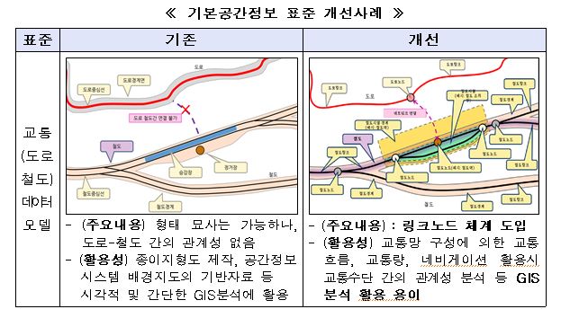
In order to resolve inconveniences in the use of basic spatial information, we decided to promote the reorganization of the basic spatial information system, including establishing data models and quality standards and improving the management and distribution system.
First, the country selected core spatial information and adjusted the items of basic spatial information to properly construct and manage it, while establishing quality standards and data models for basic spatial information items with high usability, such as roads, railways, buildings, and boundaries.
The current system that only lists detailed items has been reorganized into a system that groups similar items together and classifies them by field, type, and layer. In addition, after conducting a survey and interview survey (April - May 2017) and consultation with relevant ministries (September 2017), it was decided to exclude indoor spatial information and watershed boundaries from the basic spatial information items in consideration of usability and location compliance.
In order to minimize inconveniences in use, such as location errors when overlapping spatial information is constructed without consistent standards for each production organization, data models and product specifications for roads, buildings, etc. will be established, while a dedicated basic spatial information management organization will be designated to oversee the quality management of basic spatial information.
The Ministry of Land, Infrastructure and Transport expects that through the development of core technologies presented in this spatial information research and development roadmap, it will overcome the limitations of existing spatial information construction and updates and evolve into core technologies that support the construction of ‘intelligent space (Geo-CPS)’ and the realization of a ‘smart country.’
Comments 1
1 Comments:
Related news

Creating Three-Dimensional Drone Corridors Containing Spatial and Obstacle Information
The Ministry of Land, Infrastructure and Transport (Minister Kang Ho-in) announced that it is promoting the construction of dedicated "drone corridors" for drones to enhance safety management and accident prevention as the applications of drones in logistics transport, disaster safety, agriculture and other fields continue to expand. Drone corridors refer to drone flight paths based on three-dimensional spatial information—a new concept that includes "three-dimensional precision spatial data" necessary for safe drone flight and "obstacle information that interferes with flight." Currently, two-dimensional maps are being used for drone flights, but the absence of information regarding terrain elevation and obstacles such as transmission towers, utility poles, and high-voltage lines is causing difficulties in safely operating drones.
2016.07.25by 신윤오 기자
Applying NB-IoT technology to land registration and cadastral surveying projects
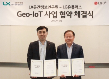
LG Uplus has announced that it has signed a memorandum of understanding with LX Korea Land and Geospatial Informatix Research Institute on a national land and transportation IoT project, and will apply NB-IoT technology to facility management projects including cadastral surveying and aging housing/building management. Cadastral surveying projects are sometimes referred to as the "resident registration of land" that records all information about national territory. LX Korea Land and Geospatial Informatix is pursuing so-called "Geo-IoT commercialization," which integrates state-of-the-art sensors and IoT technology into existing cadastral surveying projects to provide not only precise national land surveying but also collected spatial big data information to the private sector.
2017.08.08by 김자영 기자

Creating a cloud dedicated to spatial information
A forum has been opened to discuss the application of cloud technology to the management and utilization of spatial information, enabling diverse users including public institutions, private enterprises, and prospective entrepreneurs to easily leverage spatial information. The Ministry of Land, Infrastructure and Transport held a 'Spatial Information Dedicated Cloud Policy Forum' on the 20th at the Western Josun Chosun Hotel in Seoul. The forum was attended by approximately 50 participants including domestic cloud experts, cloud policy institution officials, and prospective entrepreneurs, who conducted in-depth discussions alongside topic presentations related to cloud and spatial information. Presentations were made on △the government's cloud policy direction, △introduction of cloud services dedicated to public institutions, and △the policy direction for spatial information cloud services. Cloud is expected to lower the high entry barriers for private enterprises and prospective entrepreneurs regarding spatial information, by providing specialized software and hardware necessary for processing spatial information.
2017.09.21by 김지혜 기자

Nvidia invests $5 billion in Intel
NVIDIA and Intel, leaders in global AI computing technology, are now forging ahead in providing cutting-edge solutions through NVLink-based architecture integration. NVIDIA and Intel have officially announced a strategic partnership and stated that they will jointly develop customized data center and personal computing products to accelerate diverse applications and workloads ranging from hyperscale to enterprise and consumer markets, thereby laying the foundation for the next generation computing era.
2025.09.22by 배종인 기자
.jpg)
Applied Materials Launches Environmental Protection Campaign to Mark World Cleanup Day
Applied Materials Korea (CEO Park Kwang-seon) is carrying out environmental cleanup activities with employees and their families around the Dongtan Sinricheon area on the occasion of World Cleanup Day, evolving into a company that engages with the local community beyond technological innovation.
2025.09.22by 명세환 기자












국토 특히 도로 설계에 신경을 써주세요. 욕나오는 곳이 한두군데가 아님