


LH to Create New Markets by Introducing Drones in All Construction Sectors
 Published2018.01.03 15:01
Drones are expected to be used in earnest in land and housing-related work.
The Ministry of Land, Infrastructure and Transport and the Korea Land and Housing Corporation (LH) have come up with various drone utilization plans for each stage of construction, including surveys, design, and construction management, in 215 business districts. The new drone market created as a result is expected to reach 25 billion won per year.
Meanwhile, LH has verified the use of drones in all major business areas from planning to facility maintenance through related services and pilot operations, and plans to prioritize the use of drones in 12 tasks in 5 areas※.
In the planning stage, drones can be used for on-site surveys to acquire and compensate for land needed for project implementation. In addition, drone footage is used for determining new business districts and surveying candidate sites for setting business district boundaries.
In the case of land compensation, the method of taking aerial photographs one-time and using them in the early stages of the project and conducting on-site surveys is being replaced with a method of overlapping and comparing drone images obtained periodically with cadastral maps and topographic maps.
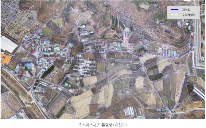
Especially for a certain period ('16. 2.~'16. 8.) As a result of pilot operation in compensation work for residential areas, national industrial complexes, etc., it was possible to easily conduct rough terrain surveys that were difficult to conduct on-site surveys, and it was also possible to use it as reliable public information for residents. When surveying candidate sites, the surrounding natural environment, elevation, slope, land use status, etc. are identified through drone images to determine the business area.
In the design stage, drones can be used for design and civil engineering BIM* construction work, such as constructing the shape and property information of the facility as 3D information identical to reality and producing digital topographic drawings suitable for public surveying. Using data captured by drones, a 3D topographic model can be created, and cross-section drawings and work volume calculations can be made through surveying programs.
Even when implementing civil engineering BIM, construction site construction management and measurement using various surveying devices that depend on manpower can be replaced by utilizing a 3D model DB based on high-resolution images.
Drones can be used effectively for tasks such as understanding the progress of construction at construction sites, process management, and safety inspections. In the case of complex construction, video data can be built for each work process to compare and analyze terrain characteristics, and construction management can also be done by overlapping various design drawings such as underground facilities, pipelines, manholes, structures, surveys, and pavements. In housing construction such as apartments, rotary-wing drones can be used to obtain images from various angles in difficult and dangerous sites, and this can be used to investigate the exterior and determine the extent of damage such as cracks and breaks.
In addition, drones are used to improve accuracy in periodic and regular inspections conducted on site, and are also used when establishing emergency recovery plans due to construction disasters such as ground collapse, rockfall, soil leaching, and structural damage.
In particular, safety inspections were mainly conducted through visual inspections, so there were limitations on high-rise exterior walls, but by using a drone's high-precision RGB image or thermal image acquisition sensor to take close-up shots, cracks can be identified and three-dimensional image analysis techniques can be used. It can detect damaged areas within the facility.
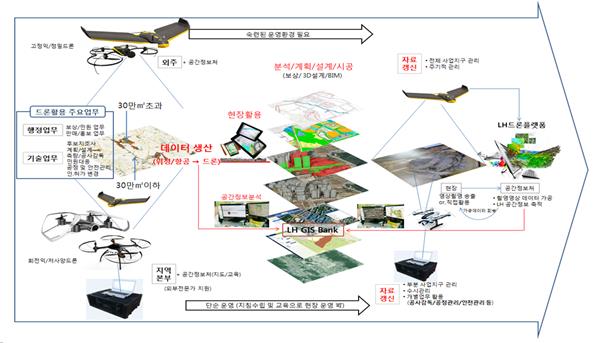
In order to process, process, and utilize various space and construction information acquired by drones, LH is establishing the world's first one-stop operation system. Through this system, all drones flying within LH business districts nationwide must receive prior approval, and will fly through ground control equipment (navigation, path tracking, smartphone view, etc.) installed on site under central control.
The images acquired at the site (business headquarters) are transmitted in real time to the central control room, and the central control room converts the received images into GIS information. The converted information is retransmitted to the site and stored in the big data server (city platform). In addition, a maintenance management system for parts and consumables is established, enabling immediate response in case of aircraft loss or malfunction due to a crash, etc.
An official from the Ministry of Land, Infrastructure and Transport said, “We expect that transparency in the construction process will be secured through smart construction management, and we expect this case to become a leading example and spread to other public institutions and the private construction industry.”
Professor Lee Seok-bae of Gyeongnam National University of Science and Technology, who conducted research on the usability of drones, added, “In addition to the direct effects of LH’s introduction of drones, such as increased work efficiency, we expect to see the prevention of safety accidents at dangerous construction sites and the creation of jobs due to the demand for technical personnel.”
관련뉴스
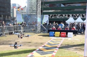
'KT 5G Drone Racing World Masters' held at Seoul Plaza
KT announced that it successfully concluded the "2017 KT 5G Drone Racing World Masters" held at Seoul Plaza in front of Seoul City Hall on the 11th. The KT 5G Drone Racing World Masters is an international drone racing competition hosted by KT at the "DRONES IN SEOUL 2017" event organized by the Seoul Metropolitan Government. This drone racing competition was notably held at Seoul Plaza, a no-fly zone within Seoul, marking the first such event in South Korea, which drew a large number of spectators. The competition featured 12 top-tier domestic players and 4 top-tier international players from countries including the United States and Japan, who engaged in thrilling matches. Following the main tournament conducted as a 16-player bracket, players Kang Chang-hyun, Kim Min-chan, Son Young-rok, and Oka (Japan) advanced to the finals to compete for the championship.
2017.11.13by 김지혜 기자
하천측량 업무에 드론 활용, 공공시장 창출한다
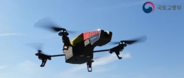
내년 3월부터 하천과 주변지형을 조사하고 상태를 모니터링 하는데 드론이 본격 활용된다. 국토교통부는 하천법에 따라 전국 국가 지방 하천을 대상으로 하천기본계획을 수립 중으로, 내년에는 하천지형조사, 하상변동조사 등 하천측량 업무에 드론이 이용될 예정이다. 이를 위해 이달부터 하상측량 시범사업을 우선 착수하며, 현재 개발 중인 표준수행절차와 품셈의 현장 적용성과 활용성을 검증할 계획이다. 시범사업은 5개 지방 국토관리청별로 한강, 낙동강, 금강, 영산강의 본류 및 지류 7개 구간을 대상으로 실시한다.
2017.12.15by 김지혜 기자
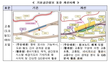
Improving the basic spatial information system to realize a smart country
국토교통부는 ‘공간정보 연구개발 혁신 로드맵’과 ‘기본공간정보 체계 개선방안’을 확정했다. 공간정보는 제4차 산업혁명 시대를 맞아 자율주행차, 드론, 스마트시티 등 신산업 발전을 지원하는 기반으로서 그 중요성이 부각되고 있으나, 국내 공간정보 기술력은 세계 최고 수준 대비 74.5%, 기술 격차는 약 3년 정도 뒤처져 있는 실정이다. 이를 극복하기 위한 연구개발도 미래 전망과 기술 수요가 제대로 반영되지 못하고, 단편적인 수요 대응 차원에서 연구개발 가능 분야 위주로 선정되어 추진되는 한계를 보여 왔다.
2017.12.21by 김지혜 기자
Ecolab and K-water Discuss Innovation Collaboration in Advanced Industry Water Management
Ecolab and the Korea Water Resources Corporation jointly discussed cooperation directions for maximizing water use efficiency in advanced industries such as semiconductors and data centers and establishing sustainable water circulation. The two companies agreed to gradually develop a long-term cooperation model that combines water resource infrastructure and water management technology to promote water efficiency optimization, water reuse, and carbon reduction.
2026.08.28by 명세환 기자

에이치에너지, 녹색기술인증 획득…솔라온케어 가동률 99.82%
에이지에너지가 태양광 발전예측 및 I-V커브 이상진단 기술로 중소벤처기업부 녹색기술인증을 획득했다. AI 기반 자산관리 플랫폼 솔라온케어는 전국 3,000개 이상 발전소에 적용되어 99.82%의 시스템 가동률과 3.7% 발전성능 개선을 달성했다. 실시간 데이터 분석을 통해 모듈 노화와 부분 음영 등 미세한 손실을 조기에 감지하고 관리함으로써 발전 수익을 보호한다.
2026.08.25by 명세환 기자











