


Creating Three-Dimensional Drone Corridors Containing Spatial and Obstacle Information
 Published2016.07.25 09:52
Pilot Project Launched in Response to Growing Demand for Drone Maps and Navigation Systems
Airspace for drones is now opening.
The Ministry of Land, Infrastructure and Transport (Minister Kang Ho-in) announced that it is promoting the construction of dedicated "drone corridors" for drones to enhance safety management and accident prevention as the applications of drones in logistics transport, disaster safety, agriculture and other fields continue to expand.
Drone corridors refer to drone flight paths based on three-dimensional spatial information—a new concept that includes "three-dimensional precision spatial data" necessary for safe drone flight and "obstacle information that interferes with flight."
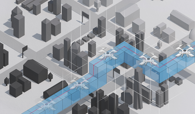
< Conceptual Diagram of Three-Dimensional Grid-Based Drone Corridor >
Currently, two-dimensional maps are being used for drone flights, but the absence of information regarding terrain elevation and obstacles such as transmission towers, utility poles, and high-voltage lines is causing difficulties in safely operating drones.
In particular, in the logistics transport sector, as interest in new industrial applications utilizing drones increases, there is a growing demand for drone maps and navigation systems for safe urban flight.
As drone operations are expected to expand from visual flight rules to beyond-visual-line-of-sight autonomous flight, the Ministry of Land, Infrastructure and Transport is promoting a pilot project for three-dimensional precision maps for drone corridors that express obstacle information to support safe drone flight.
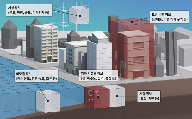
< Applications of Three-Dimensional Grid-Based Drone Corridor >
Through this pilot project, the Ministry will research specific implementation plans for nationwide drone corridor construction and methods for introducing three-dimensional spatial grid systems, while also pursuing technology development for constructing three-dimensional spatial grids and implementing drone corridors.
A three-dimensional spatial grid system is a spatial information model that represents space as three-dimensional grids by integrating data on living spaces, society, and natural phenomena, and is divided into sections so that diverse information (such as drone corridors) can be constructed for each grid.
Taking the Lead in Activating Commercial Drones in Urban Areas
Furthermore, from the five airspaces designated in the Ministry's "Drone Safety Verification Pilot Project" (December 2015)—Busan, Daegu, Jeonju, Yeongwol, and Goheung—two target areas, Jeonju and Yeongwol, have been selected to construct pilot spatial information necessary for research and apply the developed technology.
Meanwhile, on July 15th, the Ministry held a flight demonstration in Jeonju to verify obstacle information necessary for safe drone flight and factors hindering drone autonomous flight. By year-end, the Ministry plans to apply the pilot project results to logistics transport and conduct pilot operations for beyond-visual-line-of-sight autonomous drone operations.
The Ministry stated, "The concept of three-dimensional grid-based drone corridors, which is the core of this research, is still in the idea stage internationally. With proactive technology development and early commercialization, Korea can take the lead over competitor nations in activating commercial drones in urban areas, thereby contributing to the creation of new industries and jobs in alignment with the Government 3.0 policy."
Comments
Related news
Let's seize the future drone market, patent applications surge
The Korean Intellectual Property Office (headed by Commissioner Choi Dong-gyu) announced that a total of 389 drone-related patents were filed in 2015, representing a sharp increase of 161% compared to the previous year. Drone patent filings have been rapidly increasing in recent years, from only around 30 applications per year before 2012, to 126 in 2013, 149 in 2014, and reaching 389 last year.
2016.02.16by 신윤오 기자
[Reporter's Notebook] If we don't dominate the public drone market, it will all be lost to China.
The proportion of unmanned aircraft in the overall aircraft market is increasing, as confirmed by figures. The global unmanned aircraft market is projected to reach $12.5 billion in 2025 with an annual average growth rate of 10%, and the domestic unmanned aircraft market is expected to grow at an annual average rate of 22%, reaching $525 million in 2022. While the majority of the unmanned aircraft market is military-focused, the proportion of the civil market is also increasing. Military unmanned aircraft is projected to increase to $11.59 billion in 2023 at an annual average growth rate of 9%, while civil unmanned aircraft is forecasted to reach $880 million in 2023 with an impressive annual average growth rate of 35%. In particular, small commercial unmanned aircraft for civil use is expected to experience a surge in mid to long-term demand with the preparation of legislation to activate the market.
2016.06.27by 신윤오 기자

KT Hosts 'GiGA Colla Festival' for Drones and VR in Haeundae
KT announced on the 20th that it will hold the 'GiGA Collabo Festival' at Haeundae Beach in Busan, one of the most popular vacation destinations during summer holidays, from August 5th (Friday) to 7th (Sunday) for three days, allowing people to directly experience, feel, and enjoy the fastest and most innovative GiGA services. The 'GiGA Collabo Festival' features ▲the 'GiGA Drone Racing World Masters' competition, which for the first time in Korea brings together drone racing champions from 12 countries around the world and top-ranked players from each country, and ▲the e-sports 'Second GiGA Legend Match' where StarCraft legends Kang Min, Kim Taek-yong, Lee Young-ho, and Hong Jin-ho compete for the top position, along with ▲an 'Overwatch' special match, the PC room occupancy leader, and ▲GiGA VR and GiGA IoT health experience zones, making it the largest festival of this summer filled with abundant entertainment options.
2016.07.20by 장은성 기자

[Technical Contribution] Mouser: "AI Agents Help Accelerate and Standardize Industrial Field Maintenance Operations"
Abhishek Jadhav from Mouser Electronics discusses how to leverage agentic AI for predictive maintenance in industrial automation.
2026.10.23by 편집부
Schneider Electric Unveils Modular Power Solution for AI Data Centers
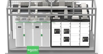
Schneider Electric has launched prefabricated power modules and power skids for AI data centers, jointly developed with NVIDIA. Based on the GB300 NVL72 reference design, the solution applies standardized design and factory pre-fabrication methods to build power infrastructure in as little as 6 months. Galaxy VXL UPS technology is integrated, with capacity options ranging from 2MW to 2.5MW.
2026.10.23by 배종인 기자











