


SK Telecom deploys drones to maintain mobile base station quality
 Published2016.09.26 17:05
Improving mobile communication quality and establishing an efficient disaster network through precise measurements
SK Telecom announced on the 26th that it is deploying drones to areas where it is difficult for people to directly measure on-site conditions, such as remote mountainous regions and high-altitude areas where new highways and railways are being constructed, to install mobile communication base stations more precisely and efficiently.
When installing mobile communication base stations, using drones allows for the accurate measurement and determination of the height of antennas to be installed on base station towers, building rooftops, or roads. In addition, it has the advantage of allowing workers to visually inspect the service area at the expected height before installation, making it easy to find the optimal installation site by identifying and removing obstacles that might interfere with service in advance.
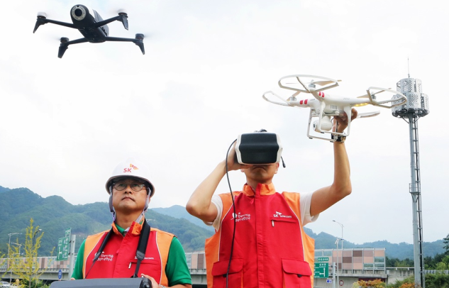
SK Telecom is currently utilizing drones capable of measuring altitude via ultrasound and allowing operators to view real-time video through dedicated goggles for the construction of new mobile communication base stations in the Gangwon region, including the newly constructed KTX section between Wonju and Gangneung, and plans to expand the use of drones nationwide through the introduction of additional equipment in the future.
Choi Seung-won, Head of Infrastructure Strategy at SK Telecom, stated, “Utilizing drones facilitates the calculation of radio wave reach and the identification of interference factors when constructing mobile communication networks in mountainous and remote areas.” He added, “We expect that accurate on-site measurements using drones will greatly aid in efficient network construction, and we plan to actively utilize drones in future mobile communication network projects, including KTX and new highway sections, as well as disaster networks.”
관련뉴스
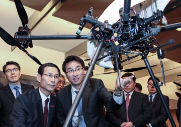
[Reporter's Notebook] If we don't dominate the public drone market, it will all be lost to China.
The proportion of unmanned aircraft in the overall aircraft market is increasing, as confirmed by figures. The global unmanned aircraft market is projected to reach $12.5 billion in 2025 with an annual average growth rate of 10%, and the domestic unmanned aircraft market is expected to grow at an annual average rate of 22%, reaching $525 million in 2022. While the majority of the unmanned aircraft market is military-focused, the proportion of the civil market is also increasing. Military unmanned aircraft is projected to increase to $11.59 billion in 2023 at an annual average growth rate of 9%, while civil unmanned aircraft is forecasted to reach $880 million in 2023 with an impressive annual average growth rate of 35%. In particular, small commercial unmanned aircraft for civil use is expected to experience a surge in mid to long-term demand with the preparation of legislation to activate the market.
2016.06.27by 신윤오 기자
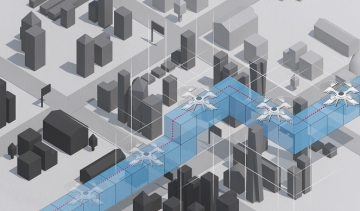
공간 및 장애물 정보 담긴 3차원 드론길 만든다
국토교통부(장관 강호인)는 물류운송, 재난안전, 농업 등 드론의 활용분야 증가에 따라 안전관리 및 사고예방을 위해 드론을 위한 전용 '드론길' 구축을 추진한다고 밝혔다. 드론길은 드론의 안전한 비행에 필요한 '3차원 정밀 공간정보'와 '비행에 방해되는 장애물 정보'를 포함한 새로운 개념의 3차원 공간정보 기반의 드론 경로를 의미한다. 현재는 드론 비행에 2차원 지도가 활용되고 있으나 지형의 높이와 송전탑, 전신주, 고압선 등 장애물 정보 부재가 없어 드론을 안전하게 운용하는데 어려움을 호소하고 있는 실정이다.
2016.07.25by 신윤오 기자
Why does Disney have so many drone patents?
A recent analysis of drone-related patents registered with the U.S. Patent Office over the past four years revealed that patents are most frequently registered in the service sector, followed by function and platform, urban infrastructure, and privacy patents, in that order. Cha Weon-yong, director of ASPEC Future Technology Management Research Institute and a representative futurologist in Korea who also serves as a government ICT convergence specialist committee member, published a report based on an intensive analysis of approximately 500 global patents related to drones, unmanned aerial vehicles (UAV), or unmanned aerial systems (UAS) registered with the U.S. Patent Office (USPTO.GOV) from June 7, 2012 to August 4, 2016. The analysis focused on 130 patents among these that were deemed to have a high likelihood of being realized within 10 to 25 years or were judged to be particularly significant.
2016.09.26by 신윤오 기자
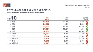
European Patent Applications Surpass 200,000 for the First Time… South Korea Maintains 5th Place, Led by Batteries and Telecommunications
According to the European Patent Office (EPO)'s 'Technology Dashboard 2025', European patent applications last year reached 201,974, surpassing 200,000 for the first time. Korean companies and inventors filed 14,355 applications, representing a 9.5% increase from the previous year and maintaining 5th place by country. Battery, digital communication, and semiconductor technologies led the growth, with Samsung ranking as the top EPO applicant for the second consecutive year and LG reaching 3rd place. The presence of major domestic cities such as Seoul, Suwon, and Yongin was also confirmed. It was also revealed that Korea's European patent strategy is expanding beyond individual technologies to span the entire industry.
2026.03.24by 명세환 기자

SK Telecom First Applies AI-Based Network Operations at Gwanghwamun K-Pop Concert
SK텔레콤이 3월 21일 서울 광화문 일대에서 열린 대형 K-팝 공연에 AI 기반 네트워크 운영 시스템을 처음 적용해 통신 품질을 관리했다고 밝혔다. 공연 전후 3시간 동안 모바일 데이터 사용량은 12.15TB로 직전 주말 같은 시간대보다 약 2배 늘었다. SK텔레콤은 AI 시스템 ‘A-One’을 활용해 5분 단위, 50m 단위로 트래픽을 감시하며 과부하 가능성에 대응했고, 임시 통신 시설과 현장 인력 운영도 병행했다. 밀집 행사와 외국인 이용 수요가 동시에 늘어나는 환경에서 AI 기반 자율 네트워크 운영의 현장 적용 가능성을 확인한 사례로 해석된다.
2026.03.23by 명세환 기자











