



KT secures maritime LTE coverage up to 200km offshore and develops 'Marine Navigation'
 Published2017.10.25 10:09
Securing LTE service coverage up to 200km offshore
KT announced on the 25th that it participated in the 'Marine Week 2017' exhibition held at BEXCO in Busan for 4 days starting on the 24th, and unveiled new solutions to minimize maritime safety accidents based on differentiated disaster safety technologies and expertise.
The solutions unveiled by KT are based on expanded maritime LTE coverage: ▲Marine Navi, a vessel safety solution for preventing collision accidents of small ships, and ▲Skyship, a unified maritime surveillance device that combines the advantages of drones and airships.
Marine Navi is an 'integrated collision avoidance solution' based on LTE and intelligent CCTV that displays maritime traffic information and maritime situation video on a single display. Basic navigation information such as location and speed of surrounding vessels collected by the Automatic Identification System (AIS) is fused and analyzed with GPS information by KT's 'Marine Navi Analysis Platform', and displays in real-time on an electronic chart the location of the vessel, distance to surrounding vessels within a 10km radius, and the possibility of collision.
Additionally, Marine Navi utilizes deep learning functionality that collects and learns various ship shapes from CCTV footage. It recognizes and alerts approaching vessels, and even when visibility is impaired due to adverse weather conditions such as sea fog, it reduces interference factors in CCTV footage based on video analysis technology and improves brightness contrast and saturation to provide navigators with clear driving visibility.
KT provides a user interface (UI) that is easy for anyone to understand regarding the information provided by Marine Navi, and when the collision risk analyzed by GPS information and video exceeds the threshold, the system provides advance warning through alarms, so it is expected that collision accidents of small vessels can be dramatically reduced.
Skyship enables stable maritime surveillance for up to 8 hours. This is an improvement over drone flight time and distance. Skyship, jointly developed by KT and small and medium enterprises, is an unmanned airship-type aircraft that combines a helium-filled airframe and propeller propulsion.
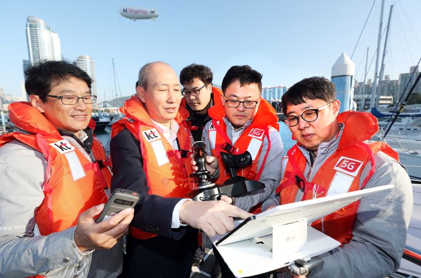
With a maximum speed of 70km/h, it can fly up to a maximum of 25km from the operator and for up to 8 hours, and has the advantage that it is unlikely to crash due to its airship form. In particular, unlike drones, Skyship can freely expand the airframe size, allowing it to carry various mission equipment such as medicines and life jackets, and utilizing the 360-degree camera and LTE communication module installed on the body, HD-quality footage captured by KT Skyship can be transmitted in real-time to a mobile surveillance platform or maritime safety control center.
Additionally, Skyship can function as a mobile base station in emergencies, making it possible to position it above disaster areas and quickly secure network coverage in disaster areas, and through the thermal imaging camera mounted on KT Skyship and LED lighting of 90,000 lumens (lighthouse level), it can perform and support not only maritime accidents but also various emergency nighttime search and rescue operations.
Going forward, KT plans to expand the scope of Skyship utilization beyond maritime safety surveillance to include monitoring of illegal fishing vessels, dissemination of warning messages in preparation for disasters, forest fire surveillance, and various other fields.
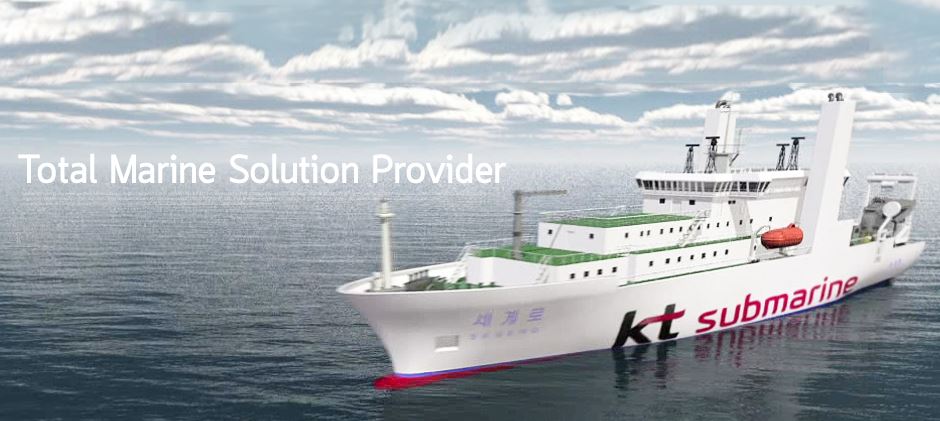
KT secures LTE service coverage up to 200km offshore (Photo source: KT Submarine)
For LTE-based maritime safety solutions such as Marine Navi and KT Skyship to be operational, securing extensive maritime LTE coverage and stable network operations are essential.
To this end, KT completed the 'Maritime LTE Quality Enhancement' project in September, expanding nationwide LTE service coverage up to a maximum of 200km offshore from land. This is the result of installing an 'ultra-directional antenna array system' developed in July of '16 and high-power LTE base stations at approximately 90 high-altitude relay stations nationwide.
According to KT LTE quality data measured in October, whereas LTE usage was almost non-existent in offshore areas more than 100km away in '15, currently numerous customers are using multimedia and SNS data services through KT's LTE network, and KT explained that maritime LTE coverage is important not only for safety but also from a service perspective.
Seong-mok Oh, President of KT's Network Division, stated "As a national enterprise, KT is striving to provide convenient services to customers and further create a safe Republic of Korea," and added "KT will continue to lead the technology of Korea's public safety communication network through continuous development of innovative technologies."
Related news
SKT Conducts Disaster Rescue Operations Through Drone Video Relay
SK Telecom announced that it has unveiled a video disaster rescue system combining its ultra-compact video live streaming equipment with drones from Soombi, a drone specialist company. The system presented by both companies enables seamless real-time viewing of ultra-high definition (Full HD) video footage captured from Soombi's industrial drones, which are resistant to rain and wind, through the LTE network from anywhere on the ground without interruption. Most existing drone video transmission methods use Radio Frequency technology, which is employed in remote-controlled vehicle operations, making relay impossible when the distance between the drone and controller exceeds approximately 1-3 km.
2017.07.17by 김지혜 기자
KT Successfully Transmits 5G Video on Highway
KT announced on the 12th that it successfully demonstrated '5G-SLT (Skylife LTE TV)' technology that connects vehicles traveling at speeds exceeding 100 km/h with 5G networks to transmit video. This marks the first time successful 5G integration has been achieved in an actual highway environment. SLT is a technology that integrates KT's LTE technology with KT Skylife's satellite broadcasting to provide high-quality video regardless of driving conditions, and was launched last July. It provides real-time broadcasting via satellite, and when satellite signals weaken due to heavy rainfall or entry into tunnels, it switches to providing real-time broadcast signals through LTE.
2017.10.13by 김자영 기자

SKT Successfully Connects LTE and 5G Equipment Frequency
SK Telecom is moving swiftly on the international stage to establish 5G standards ahead of schedule and achieve early commercialization. SK Telecom announced on the 24th that it will present research results on core 5G commercialization technologies and outline a blueprint for early 5G commercialization at the 'NGMN Forum'* to be held in Seattle on the 25th (local time).
2017.10.24by 김자영 기자
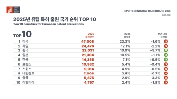
European Patent Applications Surpass 200,000 for the First Time… South Korea Maintains 5th Place, Led by Batteries and Telecommunications
According to the European Patent Office (EPO)'s 'Technology Dashboard 2025', European patent applications last year reached 201,974, surpassing 200,000 for the first time. Korean companies and inventors filed 14,355 applications, representing a 9.5% increase from the previous year and maintaining 5th place by country. Battery, digital communication, and semiconductor technologies led the growth, with Samsung ranking as the top EPO applicant for the second consecutive year and LG reaching 3rd place. The presence of major domestic cities such as Seoul, Suwon, and Yongin was also confirmed. It was also revealed that Korea's European patent strategy is expanding beyond individual technologies to span the entire industry.
2026.03.24by 명세환 기자

SK Telecom First Applies AI-Based Network Operations at Gwanghwamun K-Pop Concert
SK Telecom announced that it applied an AI-based network operation system for the first time at a large-scale K-pop concert held in the Gwanghwamun area of Seoul on March 21st, managing communication quality throughout the event. Mobile data usage during the three hours before and after the concert reached 12.15TB, approximately doubling compared to the same time slot the previous weekend. SK Telecom monitored traffic using the AI system 'A-One' in five-minute and 50-meter units to respond to potential overload situations, while also operating temporary communication facilities and on-site personnel in parallel. This case is interpreted as confirmation of the practical applicability of AI-based autonomous network operation in an environment where demand from dense events and foreign users increases simultaneously.
2026.03.23by 명세환 기자











