



A 3D National Land Management System will be established by the end of this year
 Published2020.03.06 09:00
403.5 Billion Won Invested in National Dedicated Satellite Launch, etc.
3D digital national land management will become tangible by the end of this year. A total of 403.5 billion won will be invested in 950 spatial information projects including nationwide 3D map pilot projects and 3D spatial information construction projects by local governments.
3D spatial information serves as an engine for emerging growth industries such as smart cities, autonomous vehicles, and data economy, and is a core element of location-based service industries.
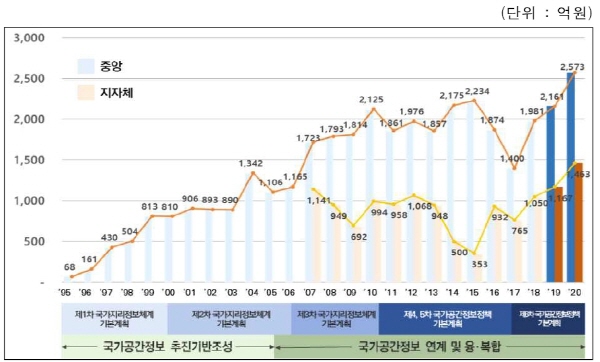
▲ National Spatial Information Project Implementation Plan Budget Scale
The Ministry of Land, Infrastructure and Transport announced on March 6 that it has finalized the 2020 National Spatial Information Implementation Plan following deliberation by the National Spatial Information Committee, which consists of a total of 30 officials including the Minister of Land, Infrastructure and Transport, and officials from central ministries such as the Ministry of Economy and Finance, Ministry of Science and ICT, Ministry of Trade, Industry and Energy, and local governments.
According to the implementation plan, projects including the launch of nationwide 3D map pilot projects, preparation for operation of dedicated national satellites (launch of first satellite in 2020), expansion of digital cadastral resurvey scale (1.56 billion won → 4.5 billion won, improvement of 200,000 parcels), and 3D spatial information construction by local governments (Seoul, Daegu, Seongnam, etc.) will be promoted.
Expansion of an integrated 3D underground space map for public safety (25 cities in the Seoul metropolitan area) and private sector opening of spatial big data analysis platforms will also be implemented to foster industry.
This plan includes 72 projects (275.3 billion won) from central ministries and 881 projects (146.3 billion won) from local governments nationwide.
The Ministry of Land, Infrastructure and Transport will promote 51 projects including nationwide 3D map pilot projects, dedicated national satellites, cadastral resurvey, and integrated underground space maps. The Ministry of Oceans and Fisheries will conduct surveys of coastal waters. The Ministry of Environment will construct natural environment geographic information databases. The Ministry of Agriculture, Food and Rural Affairs will update farm maps and construct utilization service systems. The Korea Forest Service will construct landslide risk maps, among others.
Local governments will carry out 881 projects including the 3D Virtual Seoul system (Seoul), 3D spatial information production (Daegu), heat map construction using unmanned aerial vehicles (Seongnam, Gyeonggi), and disaster risk area management systems utilizing drones (Cheongju, North Chungcheong) for administrative use.
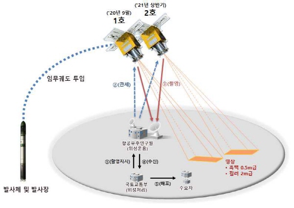
▲ Dedicated National Satellite (Image resolution 50cm panchromatic, 50cm black and white, 2m color)
At the same time, to promote industry development, private sector opening of big data analysis platforms and improvement of spatial information API utilization environments will be implemented with the goal of expanding the spatial information utilization base, while strengthening industry support projects including startup support and overseas expansion roadshows.
Son Woo-joon, Director of the National Land Information Policy Bureau at the Ministry of Land, Infrastructure and Transport, stated, "We will ensure that key projects such as nationwide 3D map pilot projects and preparation for dedicated national satellite operation produce results," and added, "We will grow the spatial information industry in line with socioeconomic conditions such as data economy and advanced technology."
Comments
Related news

[e-TECH] Stop the location service that can't even change lanes... High-precision location recognition in cm units becomes a reality
Implementing fully autonomous driving requires mapping, localization, sensing, and planning. Current GPS technology can only provide approximate location information and cannot calculate lane changes, appropriate speeds, or upcoming road conditions necessary for vehicle operation. We met with officials from a GNSS receiver module developer that has overcome the limitations of vehicle sensors and implemented positioning accuracy in the sub-centimeter range, and heard about their differentiated technology.
2020.01.07by 최인영 기자

Public frequency supply expanded more than eightfold compared to the previous year.
In 2020, a total of 2.8 GHz of public spectrum is allocated for disaster response, anomalous climate observation, and satellite communication network operations. The government is developing information-sharing methods among radar operating agencies and pursuing dedicated band discovery, taking into account the increasing radar demand for drone detection, weather observation, and maritime surveillance purposes. The supply of public spectrum represents more than an 8-fold increase compared to the previous year.
2020.01.17by 최인영 기자

Accelerating Smart Forestry by Managing Forests and Agricultural Forests via Satellites
A forestry system utilizing satellites will be established to provide rapid and accurate information on forest spaces. The Korea Forest Service announced a basic plan for the development and operation of forest satellites to realize smart forestry based on remote sensing technology, and will promote rapid response to forest disasters, provision of accurate forest information, and strengthening of inclusive international cooperation.
2020.03.03by 최인영 기자

Camera for Both Humans and Machines: ST BrightSense 5MP Dual Shutter Image Sensor
Video consumed by humans and imagery analyzed by machines impose different requirements on the sensor in terms of shutter method and wavelength band. Until now, sensors had to be separated or supplemented with companion chips and high-performance processors, and this cost and complexity became a bottleneck in vision system design. The ST BrightSense next-generation 5MP image sensor (VD5943, VD1943, VB5943, VB1943) with 2.25 µm pixels supports both global and rolling shutters, and through on-chip staggered HDR (up to 100 dB), on-chip RGB-IR separation and 5MP NIR smart upscaling, and frame-by-frame context switching, absorbs both requirements internally at the sensor level. This white paper describes the rationale, choices, trade-offs, and results of each design decision based on presentation slides and technical Q&A, and specifies application boundaries. The product is scheduled for mass production in February 2026, and evaluation and sampling are currently available.
2026.10.13by 편집부

AI-based Universal Robots Automation Solution
In manufacturing environments where declining labor populations overlap with frequent production item changes, existing programming-based robot automation requires reconfiguration from weeks to several months each time product models change. This white paper takes this flexibility gap as its starting point and synthesizes, based on webinar presentation materials and technical Q&A, what collaborative robots gain and forfeit compared to industrial robots, why process automation is transitioning from rule-based to learning-based (4th generation) approaches, and how Universal Robots' hardware, software, and partner ecosystem implement this. Additionally, it clarifies the application boundaries and limitations, including that AI Accelerator is still at the development kit stage.
2026.10.13by 편집부











