



The "spatial information" industry, which will serve as the foundation for digital twins, is being fostered.
 Published2021.05.17 10:00
Target of achieving 13 trillion won in industrial sales by 2025
Spatial information is the foundation for connecting the real and the virtual. Its importance is growing amidst the ongoing digital transformation and convergence of technology and information across all industries, centered around the Korean New Deal. Accordingly, on the 17th, the Ministry of Land, Infrastructure and Transport finalized the "3rd Basic Plan for Spatial Information Industry Promotion (2021-2025)," which focuses on fostering the spatial information industry, following deliberation by the National Spatial Information Committee.

This basic plan reflects not only the opinions of experts from industry and academia, but also the opinions proposed in a policy idea contest held for the general public in October of last year. To achieve the goal of achieving KRW 13 trillion in spatial information industry sales and entering the top 7 in national competitiveness in the spatial information field by 2025, three major strategies and 12 key tasks were presented.
◇ Strengthening industrial competitiveness through customized support for businesses.
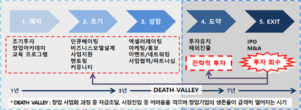
Through idea contests, technology competitions, and other initiatives, we will discover more than 30 promising startups each year and provide comprehensive support, including office space, data, and startup consulting. We will also establish a startup investment fund to support the survival and growth of startups, with a target of 5 billion won by 2025.
To foster an industrial ecosystem where large and small businesses can coexist, we plan to identify large-scale convergence projects (valued at over 2 billion won) and new technology projects such as digital twins in which large corporations can participate, while also encouraging technologically advanced small and medium-sized enterprises to participate in projects undertaken by large corporations.
A ‘standard for spatial information service fees’ will also be established to ensure appropriate fees for spatial information services.
◇ Advancement of spatial information distribution and utilization systems
We plan to expand the provision of data analysis functions tailored to public and private sector needs through a spatial big data analysis platform that spatially analyzes various data, including administrative and SNS information, and visualizes them on maps. We also plan to operate a spatial information data voucher to support data purchases by startups and small and medium-sized enterprises.
In addition, satellites, aviation, and drones We will expand the private access to various types of images and establish a platform that can analyze satellite information and various statistics through convergence.
High-precision 3D data with restricted disclosure, such as precision road maps and satellite images, will be provided promptly through the National Geographic Information Institute's national information platform with security measures such as encryption. Furthermore, standards will be developed for new technology fields such as digital twins, and pre- and post-management of the application of standards to spatial information projects will be strengthened to foster an environment for data linkage and sharing.
◇ Development of future core technologies and fostering convergent talent
The "Digital National Land Information Technology Development" R&D project, which will invest KRW 90.8 billion (based on a preliminary feasibility study) from 2022 to 2026 to develop technologies that refine, automate, and real-time the collection and processing of spatial information, will advance the "digital twin national land."
We will also develop AI-based analysis and processing technologies to enable the private sector to easily utilize digital twin data. We will also focus on disseminating R&D results, such as establishing a shared R&D testbed in the new National Geographic Information Institute building and operating a technology brokerage platform.
Furthermore, to foster talent equipped with spatial information knowledge, AI, and drones, we will strengthen our educational infrastructure by establishing convergence departments, curricula, and technical qualifications. We will also promote job creation through initiatives such as the introduction of a youth internship program and the operation of a job and employment support platform.
Comments
Related news
.jpg)
"Drone taxis are taking off." The Ministry of Land, Infrastructure and Transport and the Seoul Metropolitan Government demonstrate 'UAM' in the city center.
Urban air mobility has recently drawn attention as an alternative to solve ground traffic congestion in major metropolitan areas. Leading countries worldwide are accelerating the development of electric-powered vertical takeoff and landing aircraft. The Ministry of Land, Infrastructure and Transport and Seoul City jointly held demonstration events for drone delivery and taxi services in Yeouido. The Ministry of Land, Infrastructure and Transport announced that it will smoothly implement the K-UAM roadmap through industry-academic-research-government collaboration, with the aim of commercialization in 2025 based on this demonstration.
2020.11.12by 명세환 기자

The spatial information industry has seen a surge in the number of businesses, driven by increased public sector orders.
The spatial information industry is an industry that produces, processes, and distributes digital maps, cadastral maps, and three-dimensional maps related to the locations of objects, or provides services by converging and combining with other sectors. Citing the 2020 Spatial Information Industry Statistics Survey, the Ministry of Land, Infrastructure and Transport announced that as of the end of 2019, the domestic spatial information industry's revenue was 9.339 trillion won, the number of workers was 65,356, and the number of business establishments was 5,589.
2021.01.07by 이수민 기자
Digital Twin, Not Just a Reality Copy, but “Interconnection Technology Between Other Digital Twins” Is Needed
As the spread of social distancing imposes constraints on operating in conventional ways, there is a growing demand for innovation in business processes to deliver operational efficiency equivalent to or exceeding that of the past. The government has identified digital twin as one of the ten key initiatives to drive digital transformation. While digital twin initially garnered attention as a means of manufacturing innovation, following Singapore's government's release of the Virtual Singapore platform—which digitalizes social essential infrastructure and urban information as data to enhance city operational efficiency—digital twin has become established as an idea that brings positive changes not only to industries but to all aspects of human life.
2021.03.02by 이수민 기자

Refrigerator shutdown shakes food supply chain…'OT security' emerges as critical management priority
Supermarket refrigeration and freezing equipment across France was paralyzed by cyberattacks, highlighting the importance of OT (Operational Technology) security. Attackers infiltrated internet-connected control systems and manipulated temperature settings and defrost cycles, resulting in mass food disposal, store operation disruptions, and fire hazards. Notably, instead of installing malware, the attackers exploited existing defrost functions to disguise abnormal operations as normal activities. Experts warn that advances in AI are lowering the barrier to entry for attacks. They emphasize that companies must protect physical safety and supply chains through securing OT asset visibility, segregating IT and OT networks, controlling remote access, managing legacy equipment, and establishing anomaly detection systems.
2026.10.14by 배종인 기자

Camera for Both Humans and Machines: ST BrightSense 5MP Dual Shutter Image Sensor
Video consumed by humans and imagery analyzed by machines impose different requirements on the sensor in terms of shutter method and wavelength band. Until now, sensors had to be separated or supplemented with companion chips and high-performance processors, and this cost and complexity became a bottleneck in vision system design. The ST BrightSense next-generation 5MP image sensor (VD5943, VD1943, VB5943, VB1943) with 2.25 µm pixels supports both global and rolling shutters, and through on-chip staggered HDR (up to 100 dB), on-chip RGB-IR separation and 5MP NIR smart upscaling, and frame-by-frame context switching, absorbs both requirements internally at the sensor level. This white paper describes the rationale, choices, trade-offs, and results of each design decision based on presentation slides and technical Q&A, and specifies application boundaries. The product is scheduled for mass production in February 2026, and evaluation and sampling are currently available.
2026.10.13by 편집부











