This page was machine-translated and may differ from the original. View original
Strengthening government support for improving sensor recognition range weaknesses and precision maps
Domestic companies focus on usability from precision map construction to utilization
E4ds news, conference held on September 30th on the topic of precision maps
Domestic companies focus on usability from precision map construction to utilization
E4ds news, conference held on September 30th on the topic of precision maps
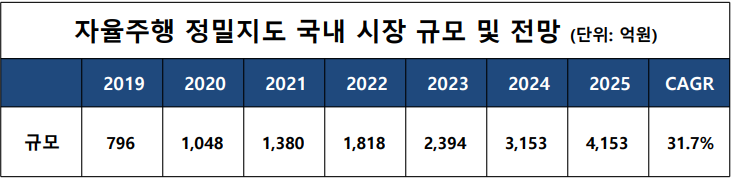
The domestic precision map market size, which was only KRW 79.6 billion in 2019, is expected to reach KRW 415.3 billion in 2025, recording an average annual growth rate of 31.7%.
The Ministry of SMEs and Startups (hereinafter referred to as the MSS) predicted in its ‘SME Technology Roadmap’ that the market size of precision maps will grow significantly due to the expansion of existing navigation technologies and businesses and the creation of new industries due to limitations in sensors used in autonomous driving and strengthened policy support related to the construction of precision maps.

▲ Domestic market size and outlook for autonomous driving precision maps (Source: Bizwit Research & Consulting LLP (2021), Global HD Map for Autonomous Vehicles Market Size, reprocessed)
Most companies, except Tesla, agree that high-precision road maps are essential infrastructure for autonomous driving.
Autonomous driving sensors have a limited recognition range of about 250m, making it difficult to respond to complex traffic environments such as irregular sections and accidents.
Precision maps compensate for the weaknesses of these sensors.
It contributes to minimizing the risk of accidents that may occur due to cognitive performance errors in autonomous driving and building a stable and reliable autonomous driving system.
The government also recognizes the importance of these detailed maps and is putting effort into building them.
In October of the year before last, the Ministry of Land, Infrastructure and Transport announced a plan to complete the construction of detailed maps of approximately 14,000 km of national highways by 2022.
By the end of 2022, a high-precision road map of approximately 20,000 km will be constructed, centered on trunk roads across the country, along with approximately 6,000 km of national highways and major city centers that have been completed to date.
Companies are taking various actions, such as forming consortiums and participating in government projects related to precision maps.
Inavi Systems is participating in the national research project, ‘Development of Level 4 autonomous driving vehicle platform technology based on designated areas (Point-to-Point)’ among the ‘Autonomous Driving Technology Development Innovation Project’ by forming a consortium with Sonnet.
In the project, iNavi Systems is responsible for the 'development of its own map engine and route generation algorithm' and is researching its own hybrid map that only provides trajectory information estimated by autonomous vehicles through point-to-point routing using a precise map existing on a server.
Mobile Tech, which received investment from Naver's startup incubation organization D2SF, participated in the National Geographic Information Institute's precision map renewal project and passed the test survey with its own developed precision road map production equipment.
Mobiltech developed its own MMS system based on its technological capabilities and has been supplying precision maps to approximately 30 domestic locations, including large domestic corporations and research institutes.
/> It is expected that the National Geographic Information Institute's precision road map renewal project will be accelerated through the MMS hardware of Mobilech, which is participating in this precision road map renewal project.
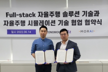
Morai, which developed an autonomous driving simulation platform, possesses the technology to build a digital twin based on precision map data.
This allows the simulator to reflect actual traffic conditions on the road, allowing autonomous vehicles to undergo verification before going out on actual roads.
Morai said that he developed a simulation environment with a margin of error of 10 cm using high-precision map data provided by the government and companies, and that he developed an algorithm that can automatically create an autonomous driving simulation environment using the data.
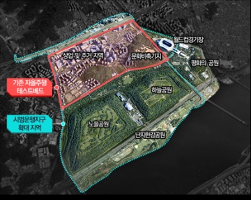
In particular, Morai's technological prowess was recognized through his participation in the development of an autonomous driving simulator that the Seoul Metropolitan Government opened free of charge to promote autonomous driving technology.
Autonomous driving sensors have a limited recognition range of about 250m, making it difficult to respond to complex traffic environments such as irregular sections and accidents.
Precision maps compensate for the weaknesses of these sensors.
It contributes to minimizing the risk of accidents that may occur due to cognitive performance errors in autonomous driving and building a stable and reliable autonomous driving system.
The government also recognizes the importance of these detailed maps and is putting effort into building them.
In October of the year before last, the Ministry of Land, Infrastructure and Transport announced a plan to complete the construction of detailed maps of approximately 14,000 km of national highways by 2022.
By the end of 2022, a high-precision road map of approximately 20,000 km will be constructed, centered on trunk roads across the country, along with approximately 6,000 km of national highways and major city centers that have been completed to date.
Companies are taking various actions, such as forming consortiums and participating in government projects related to precision maps.
Inavi Systems is participating in the national research project, ‘Development of Level 4 autonomous driving vehicle platform technology based on designated areas (Point-to-Point)’ among the ‘Autonomous Driving Technology Development Innovation Project’ by forming a consortium with Sonnet.
In the project, iNavi Systems is responsible for the 'development of its own map engine and route generation algorithm' and is researching its own hybrid map that only provides trajectory information estimated by autonomous vehicles through point-to-point routing using a precise map existing on a server.
Mobile Tech, which received investment from Naver's startup incubation organization D2SF, participated in the National Geographic Information Institute's precision map renewal project and passed the test survey with its own developed precision road map production equipment.
Mobiltech developed its own MMS system based on its technological capabilities and has been supplying precision maps to approximately 30 domestic locations, including large domestic corporations and research institutes.
/> It is expected that the National Geographic Information Institute's precision road map renewal project will be accelerated through the MMS hardware of Mobilech, which is participating in this precision road map renewal project.
Morai, which developed an autonomous driving simulation platform, possesses the technology to build a digital twin based on precision map data.
This allows the simulator to reflect actual traffic conditions on the road, allowing autonomous vehicles to undergo verification before going out on actual roads.
Morai said that he developed a simulation environment with a margin of error of 10 cm using high-precision map data provided by the government and companies, and that he developed an algorithm that can automatically create an autonomous driving simulation environment using the data.
In particular, Morai's technological prowess was recognized through his participation in the development of an autonomous driving simulator that the Seoul Metropolitan Government opened free of charge to promote autonomous driving technology.

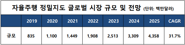
▲ Global market size and outlook for autonomous driving precision maps (Source: Bizwit Research & Consulting LLP (2021), Global HD Map for Autonomous Vehicles Market Size, reprocessed)
The global market size is expected to grow to $4.358 billion by 2025, and HERE, acquired by a consortium of BMW, Audi, and Mercedes-Benz for $3.1 billion in 2016, is leading the global market and is currently building digital maps.
There is also a lot of interest in standards.
ISO TC204 and several forums discuss standardization of precision maps that can be utilized in the autonomous driving sensor fusion precision positioning process.
In particular, ISO TC204 Working Group 3 is a working group that is conducting standardization on databases related to intelligent transport systems and services in relation to map specifications that can be used as precision maps for precise positioning in autonomous driving.
Meanwhile, as the importance of high-precision maps in the autonomous driving industry is constantly mentioned, e4ds news is holding the '2022 e4ds Automotive Tech Concert' webinar.
This conference will be a place to learn about precision map standardization issues and share the precision map technology and utilization of domestic companies.
Speakers include Park Hyeon-jin, Group Leader of Moray SW Module Group, ETRI Senior Researcher Yoo Jae-jun, iNavi Systems Director Park Jin-geun, and Mobiltech Headquarters Director Yoo Hyeong-gon.
The '2022 e4ds Automotive Tech Concert' will be held every Friday in October, one session at a time, starting at 10:30 AM. On the 7th, a session by Park Hyun-jin, Group Leader of Moray SW Module Group, will be held at e4ds EEWEBINAR. Applications for participation can be made on the e4ds homepage.
There is also a lot of interest in standards.
ISO TC204 and several forums discuss standardization of precision maps that can be utilized in the autonomous driving sensor fusion precision positioning process.
In particular, ISO TC204 Working Group 3 is a working group that is conducting standardization on databases related to intelligent transport systems and services in relation to map specifications that can be used as precision maps for precise positioning in autonomous driving.
Meanwhile, as the importance of high-precision maps in the autonomous driving industry is constantly mentioned, e4ds news is holding the '2022 e4ds Automotive Tech Concert' webinar.
This conference will be a place to learn about precision map standardization issues and share the precision map technology and utilization of domestic companies.
Speakers include Park Hyeon-jin, Group Leader of Moray SW Module Group, ETRI Senior Researcher Yoo Jae-jun, iNavi Systems Director Park Jin-geun, and Mobiltech Headquarters Director Yoo Hyeong-gon.
The '2022 e4ds Automotive Tech Concert' will be held every Friday in October, one session at a time, starting at 10:30 AM. On the 7th, a session by Park Hyun-jin, Group Leader of Moray SW Module Group, will be held at e4ds EEWEBINAR. Applications for participation can be made on the e4ds homepage.
본 기사에 대한 정정·반론·추후보도 청구는 보도 청구 안내를, 그간 게재된 보도문은 정정·반론보도 모아보기를 참고해 주세요.