



NVIDIA Unveils 'Drive Map', a Self-Driving Assistance Platform
 Published2022.04.04 15:52
지상 실측지도 엔진·크라우드 소싱지도 엔진 구성
엔비디아는 4일 GTC 2022 키노트에서 안정성과 자율성을 갖춘 멀티모달(Multi Modal) 매핑 플랫폼인 엔비디아 드라이브 맵(NVIDIA DRIVE Map)을 공개했다.
드라이브 맵은 2024년까지 북미와 유럽, 아시아 내의 50만km 도로에 대해 실측 조사 수준의 지상 지도를 제공할 예정이다.
드라이브 맵에는 △카메라 △레이더 △라이다 모달리티로 사용할 수 있는 여러 위치식별(localization) 레이어가 포함됐다. 드라이브 맵은 지도의 각 레이어에 따라 독립적으로 위치 식별을 할 수 있어 최고 수준의 자율성에 필요한 다양성과 다중성을 제공한다. 카메라 위치식별 레이어는 △차선 구분선 △도로 표시 △도로 경계 △신호등 표지판 △기둥과 같은 지도 속성으로 구성된다.
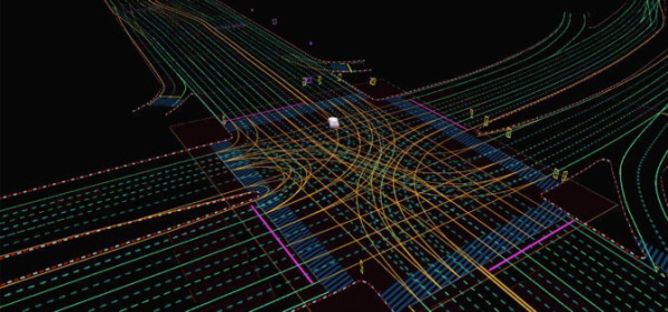
▲ 드라이브 맵 시맨틱(semantic) 위치식별 레이어
레이더 위치식별 레이어는 레이더 리턴(return)의 집합적 포인트 클라우드(point cloud)이다. 특히 카메라의 부하가 높은 조명 조건이나 카메라나 라이더에 부하가 걸리는 악천후 상황에서 유용하다.

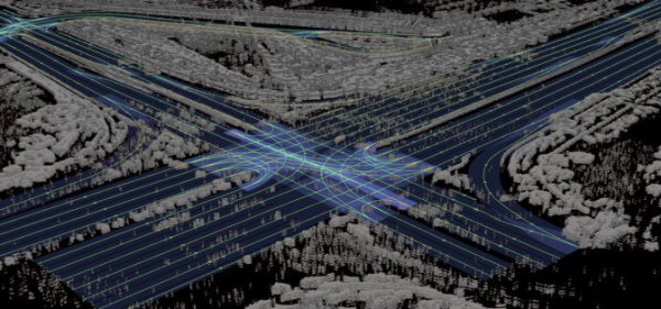
▲ 드라이브 맵 레이더 위치식별 레이어
일반적인 지도 속성으로는 식별이 불가능한 교외 지역에서도 레이더 위치 식별이 유용해 드라이브 맵은 레이더 리턴을 생성하는 주변 물체를 기반으로 위치를 잡아낼 수 있다. 라이다 복셀(voxel) 레이어는 환경을 가장 정확하고 안정적으로 표현한다. 또한 카메라와 레이더로는 달성할 수 없는 정확도인 5cm 해상도로 세계를 3D로 표현한다.
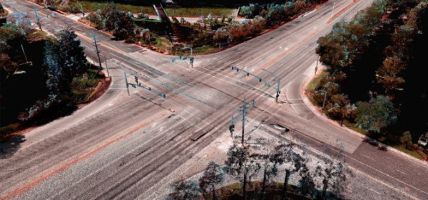
▲ 드라이브 맵 라이다(Lidar) 복셀 위치 식별 레이어
지도에 위치 식별을 마치면, 드라이브 맵은 지도가 제공하는 상세한 시맨틱 정보를 이용해 사전에 계획을 세우고 안전한 운전 결정을 내릴 수 있다.
드라이브 맵은 △지상 실측 지도 엔진 △크라우드 소싱 지도 엔진으로 구성된 두 개의 지도 엔진으로 만들어져 지구 규모의 지대에 대한 전체 정보를 수집하고 유지한다. 이 접근 방식은 양측의 장점을 결합해 측량 전문 자동차로 cm 수준의 정확도를 달성할 뿐 아니라 수백만 대의 승용차가 지속적으로 지도를 업데이트하고 확장해야 달성할 수 있는 최신성과 규모를 달성한다.
지상 실측 엔진은 딥맵 실측 지도 엔진을 기반으로 하여 지난 6년간 개발 및 검증된 기술이다. AI 기반의 크라우드 소싱 엔진은 주행하는 수백만 대의 자동차로부터 업데이트된 지도 정보를 수집하여 새로운 데이터를 클라우드에 지속적으로 업로드한다. 그런 다음 데이터는 옴니버스(Omniverse)에 모여 지도 업데이트에 사용되며, 몇 시간내로 실제 차량에 최신 지도 정보를 무선 업데이트한다.
또한 드라이브 맵은 데이터 인터페이스인 드라이브 맵스트림(MapStream)을 통해 드라이브 맵스트림 요구 사항을 충족하는 승용차가 카메라, 레이더 및 라이더 데이터를 사용해 지도를 지속적으로 업데이트하도록 지원한다.
드라이브 맵은 인공지능이 최적의 주행 결정을 내리도록 지원하는 것은 물론 심층 신경망(DNN) 훈련 및 테스트와 검증을 위한 지상 실측 훈련 데이터를 생성하면서 자율주행차(AV) 개발을 가속화한다.
이 중심에는 실제 지도 데이터가 로딩되고 저장되는 옴니버스가 있다. 옴니버스는 지도 측량 자동차와 수백만 대의 승용차가 지속적으로 업데이트하고 확장하는 디지털 트윈을 지구 규모로 표현한다.
옴니버스에 내장된 자동 콘텐츠 생성 도구를 통해 상세히 표현된 지도는 엔비디아 드라이브 심(Sim)으로 사용될 수 있는 주행 가능한 시뮬레이션 환경으로 변환된다. △도로 고도 △도로 표시 △섬 △교통 신호 △표지판 △수직 기둥과 같은 지형적 특징들은 cm 수준의 정확도로 정확하게 복제된다. 자율주행차(AV) 개발자는 물리적 기반 센서 시뮬레이션 및 도메인 랜덤화를 통해 시뮬레이션 환경을 사용해 실제 데이터에서 사용할 수 없는 훈련 시나리오를 생성할 수 있다.
또한 시나리오 생성 도구를 적용해 AV 소프트웨어를 디지털 트윈 환경에서 테스트한 다음 자율주행차를 실제 환경에 배치할 수 있다. 또, 디지털 트윈은 자동차가 실제 세계에서 운행될 때의 환경을 가상으로 완벽하게 구현한 장면을 운행자들에게 제공함으로써 필요시 원격 조작이 가능하다.
Comments
Related news
.jpg)
Intel and Nvidia Engage in Fierce Competition in Autonomous Driving Technology
Intel and NVIDIA announced latest technologies such as SoCs and expanded partnerships, signaling intense competition to seize the autonomous driving technology throne. Intel unveiled the EyeQ® Ultra system-on-chip. In response, NVIDIA announced the latest generation Drive Hyperion 8 platform.
2022.01.06by 성유창 기자
20 of the world's top 30 electric vehicle manufacturers use NVIDIA
BYD and Lucid Motors have adopted NVIDIA Drive for their next-generation vehicles, establishing NVIDIA as an AI computing platform adopted by 20 of the top 30 electric passenger vehicle manufacturers worldwide.
2022.03.30by 성유창 기자
NVIDIA Handles RTX GPUs' Challenging Workflows
Nvidia (CEO Jensen Huang), a leader in AI computing technology, has unveiled its latest RTX GPUs that support demanding workflows and hybrid work.
2022.04.04by 배종인 기자
[e4ds Tech Day 2026 ⑨] Sim Sang-gyu, Autocrypt CTO: "In the Physical AI Era, Automotive Security Must Extend Beyond the Vehicle"
At e4ds Tech Day 2026, Sim Sang-gyu, CTO of Autocrypt, explained automotive cybersecurity strategies in the era of Physical AI and SDV (Software-Defined Vehicle). Automobiles are evolving as part of an ecosystem connected to AI, cloud, chargers, IoT, and robots, and he emphasized that the scope of security must expand beyond the vehicle interior to the entire connected environment. In particular, AI model tampering, adversarial attacks, OTA updates, and EV charger hacking were identified as major threats. He explained that response measures require zero trust, AI model integrity protection, intrusion detection, Security by Design and Default, and full lifecycle security management, and that proactive security system establishment beyond regulatory compliance is critical for securing future mobility competitiveness.
2026.10.12by 배종인 기자

Practical HIL Construction Strategy for Automotive and Off-Highway Controller Validation
As vehicle E/E architecture transitions to zonal structures and shifts to software-defined vehicles (SDV), the number of controllers (ECUs) requiring validation and software complexity are surging dramatically. Meanwhile, real vehicle testing cannot provide repeated verification under identical conditions and entails lead time and safety concerns. This white paper explains the principles of HIL (Hardware-in-the-Loop) validation and the structure of the NI platform composed of PXI, SLSC, and VeriStand, and through two actual implementation cases—Camera Record & Replay HIL for In-Cabin Monitoring Controller (ICMU) and Forklift Controller (VCU) HILS—describes how controller-level regression testing becomes possible. Additionally, it explicitly states application boundaries and limitations, such as lack of A2B support.
2026.10.12by 편집부











