


Geographic Information Institute produces precision maps based on ISO specifications.
 Published2022.10.20 14:49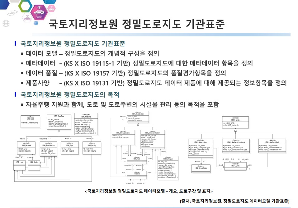
ISO TC 204 actively discusses standardization related to intelligent transport systems.
Includes modeling and exchange of vehicle specifications and infrastructure static information on the road.
Defining road map specifications to support autonomous driving systems beyond navigation.
On the 14th, e4ds hosted a webinar at the 2022 e4ds Automotive Tech Concert, inviting ETRI's Senior Researcher Jaejun Yoo to discuss the topic of "Precision Road Map Standardization Trends for Autonomous Driving."
The Cognitive and Transportation ICT Lab, which includes Senior Researcher Jaejun Yoo, conducts research and development with the goal of supporting safe and efficient driving by monitoring vehicles, drivers, assistants, and vehicle status.
Additionally, we are conducting R&D to provide services and functions that link some traffic information and ICT system information.
Research Fellow Yoo stated the significance of his participation in this webinar, saying, “The importance of precision maps is being highlighted in autonomous driving,” and “I plan to provide a general overview of how the standardization of precision maps is progressing.”
Precision road maps are designed to support autonomous driving. This is a 3D digital map constructed with 25cm accuracy that includes necessary lane information, regulatory and safety information, and various road and sign facilities.
There are many domestic and international examples of creating, constructing, and utilizing high-precision maps. Overseas, large companies such as HERE and TomTom RoadDNA are building them.
Several automakers form a consortium to create map specifications, some of which are open, but a significant portion is shared only within the consortium.
Although data within the consortium can be used only by signing up, many people say that it is not easy to use because it is so expensive.
Research Fellow Yoo continued, “There is an inter-ministerial agreement that states, ‘The National Geographic Information Institute builds and distributes high-precision road maps in our country,’ so the National Geographic Information Institute is currently creating and distributing specifications for high-precision road maps,” and explained, “If you apply to the National Geographic Information Institute, you can download and use the data.”
The National Geographic Information Institute's precision map specifications were compiled based on specifications created by ISO.
ISO TC 204 discusses standardization related to Intelligent Transport Systems (ITS).
Twenty-one working groups have been formed to define and discuss standardization of the systems through which information should be shared and utilized.
Among them, Working Group 3 is working on standardization of map data for geographic information spatial information required in transportation and ITS.
△Includes methods for specifying vehicle locations on the road, △modeling and exchanging static information about infrastructure, and △modeling and exchanging dynamic information between vehicles and infrastructure.
ISO 20524 is a representative standard related to high-precision road maps.
The standard originally called GDF (Geographic Data File) was intended to be used when receiving navigation services in vehicles. It was a standard that defined the specifications for parts of road maps, and it was continuously updated and expanded into the current standard called ISO TC 20524-2.
It is a map that can be utilized in fields such as C-ITS, as it has a scope that defines 'specifications for road maps that can support not only existing navigation but also autonomous driving systems.'
One of the keywords related to precision maps is LDM (Local Dynamic Map).
While the precision map occupies a static part, the LDM is classified as dynamic information.
Dynamic information includes things like road construction and signal changes, and discussions are underway on how to establish a framework for exchanging this information.
One of the topics being actively discussed in ISO TC 204 Working Group 3 is ISO/TS 22726.
When only a portion of a precision map has changed or only a portion of it needs to be transmitted for use, it is difficult to transmit the map specifications as data, so standards are being discussed regarding whether only the dynamic portions can be changed.
In response to a question about updating the precision road map, Researcher Yoo explained, “The National Geographic Information Institute is updating it,” and “Precision road maps have already been built for the entire nation’s highways, and as we expand to national roads, we are also continuously updating the parts that were previously built.”
He added, “The update cycle is not fixed, and we apply various methods according to the situation when data specifications or terrain change.”
Meanwhile, e4ds will hold the '2022 e4ds Automotive Tech Concert&rs' at 10:30 am on the 21st.On the third day, Jin-Geun Park, Director of iNavi Systems, will present on the topic of ‘Hybrid Map for Point-to-Point Movement Based on Designated Areas.’
Comments
Related news
.jpg)
“Completion of construction of nationwide precision road map by 2030”
The Ministry of Land, Infrastructure and Transport (hereinafter referred to as the Ministry) will systematically advance the construction of high-precision road maps, which are essential infrastructure for autonomous driving, and increase the utility of map data by opening it to the private sector.
2022.09.21by 성유창 기자

Moray to Present Autonomous Driving Simulation at the 2022 e4ds Automotive Tech Concert
Morai will share the relationship between simulation and precision road maps, how precision map data was utilized, and technical pipelines and work accomplished through a free online webinar.
2022.09.23by 성유창 기자

Autonomous driving requires proof of integrity through precision map-based simulations.
e4ds held a session to share precision map technology and its applications among domestic companies, and conducted a webinar with Park Hyun-jin, Group Lead of the Software Module Group at Morai, which possesses automatic digital twin construction technology based on precision maps.
2022.10.11by 성유창 기자

Morai: "Currently Collaborating with Domestic Automotive OEMs and Tier 1s"
At the 2022 e4ds Automotive Tech Concert, Park Hyun-jin, Group Manager of Morai Software, who presented on "Precision Road Map Utilization and Seoul Autonomous Vehicle Simulator" on the 7th, has provided answers to questions that could not be addressed due to time constraints.
2022.10.13by 성유창 기자

[Interview] Yoo Hyeong-gon, Head of Mobiltech Headquarters, “Mobiltech Road Facility/Object Detection Technology Reduces Precision Map Update Speed”
We invited Mobil Tech, which possesses a point cloud map comparison update algorithm and technology capable of extracting only changed portions by comparing with previously constructed point clouds, to the '2022 e4ds Automobit Tech Concert,' and spoke with Yoo Hyung-gon, Head of the Mobil Tech Division, who participated as a speaker.
2022.10.20by 성유창 기자











