



IceEye strengthens Earth observation data collection capabilities
 Published2023.11.14 15:03
.jpg)
▲ SpaceX Transporter launch scene (Photo courtesy of SpaceX)
ICEYE, a global leader in continuous Earth observation using radar imaging satellites and a specialist in natural disaster solutions, has strengthened its Earth observation data collection capabilities through the launch of a new satellite.
Iceeye announced on the 11th that it had successfully launched four new SAR (Synthetic-Aperture Radar) satellites and expanded its satellite constellation.
This launch was carried out from Vandenberg Space Force Base in California, USA, via Exolaunch using SpaceX’s Transporter-9, which performs a small satellite rideshare mission.
Communication settings with each spacecraft have been successfully established, and routine initial operations are currently being carried out.
IceEye has deployed 31 satellites from 2018 to the present and is further strengthening its global leadership in the field of SAR satellite technology. IceEye, which owns and operates the largest SAR satellite constellation, supports customers in accessing data most quickly in emergency situations and provides the highest frequency of return visits for high rates of recurring phenomena.
Rafal Modrzewski, co-founder and CEO of Iceeye, stated, “This launch and deployment is not merely the addition of a satellite to the constellation, but a testament to Iceeye’s commitment to continuously pursuing technological advancements to support our customers. We are deploying a resilient constellation equipped with high return rates and cutting-edge capabilities to meet the requirements of even the most demanding customers who require imagery at rapid intervals.”
The capabilities of the four third-generation IceEye satellites launched on this day include Spot Fine mode, which can collect images of the Earth with a ground resolution of 50 cm by further developing the existing IceEye satellite imaging capabilities, and Dwell mode, which can rapidly detect changes on the ground in near real-time using advanced collection technology.
John Cartwright, Data Product Manager at Iceeye, said, “The demand for high-resolution satellite imagery capacity from Iceeye’s customers worldwide continues to grow. These customers are using Iceeye’s imagery for actionable information and reliable decision-making,” adding, “Through three satellite launches in 2023, we have once again demonstrated Iceeye’s commitment to building and operating the largest SAR satellite constellation.”
The satellites recently launched by IceEye include next-generation satellites being manufactured and operated by European and American teams. Iceeye's U.S. subsidiary, headquartered in Irvine, California, is licensed by the National Oceanic and Atmospheric Administration (NOAA) to manufacture and operate satellites to support U.S. government and corporate clients.
Approximately 70% of the Earth is covered by clouds, and depending on the time of day, half of the region remains in darkness. SAR satellites generate images by irradiating the ground with microwaves and analyzing the energy reflected back to the satellite. Because SAR provides excellent image quality during both day and night, as well as under all weather conditions, it can deliver superior results compared to conventional electro-optical imaging in observation and exploration applications. This capability makes it highly suitable for applications such as insurance, natural disaster response and recovery, national security, defense and intelligence, humanitarian relief, and climate change observation.

Comments
Related news
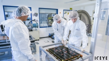
Ice Eye Begins Full-Scale Satellite Service Customer Support
Earth observation company ICEYE, which operates the world's largest SAR (Synthetic-Aperture Radar) satellite constellation, has established a dedicated business division for satellite sales and customer satellite management, and has begun full-scale customer support operations.
2022.07.21by 강정규 기자

Iceeye Wins NASA Mission
ICEYE US has received its first task order under a BPA (Blanket Purchase Agreement) with NASA announced earlier this year.
2023.08.18by 배종인 기자
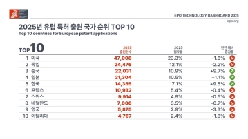
European Patent Applications Surpass 200,000 for the First Time… South Korea Maintains 5th Place, Led by Batteries and Telecommunications
According to the European Patent Office (EPO)'s 'Technology Dashboard 2025', European patent applications last year reached 201,974, surpassing 200,000 for the first time. Korean companies and inventors filed 14,355 applications, representing a 9.5% increase from the previous year and maintaining 5th place by country. Battery, digital communication, and semiconductor technologies led the growth, with Samsung ranking as the top EPO applicant for the second consecutive year and LG reaching 3rd place. The presence of major domestic cities such as Seoul, Suwon, and Yongin was also confirmed. It was also revealed that Korea's European patent strategy is expanding beyond individual technologies to span the entire industry.
2026.03.24by 명세환 기자

SK Telecom First Applies AI-Based Network Operations at Gwanghwamun K-Pop Concert
SK Telecom announced that it applied an AI-based network operation system for the first time at a large-scale K-pop concert held in the Gwanghwamun area of Seoul on March 21st, managing communication quality throughout the event. Mobile data usage during the three hours before and after the concert reached 12.15TB, approximately doubling compared to the same time slot the previous weekend. SK Telecom monitored traffic using the AI system 'A-One' in five-minute and 50-meter units to respond to potential overload situations, while also operating temporary communication facilities and on-site personnel in parallel. This case is interpreted as confirmation of the practical applicability of AI-based autonomous network operation in an environment where demand from dense events and foreign users increases simultaneously.
2026.03.23by 명세환 기자
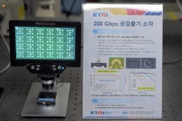
ETRI Develops 200Gbps Photodetector… Initiates Localization of Optical Receivers for AI Data Centers
The Electronics and Telecommunications Research Institute (ETRI) has developed a photodetector device that processes optical signals of approximately 200Gbps per channel for the first time in Korea. This device is a component that converts optical signals into electrical signals and determines the reception performance of AI data centers and 5G/6G communication networks. ETRI achieved bandwidth of 70GHz or higher and optical responsivity of 0.75A/W or higher, and integrated an indium phosphide lens on the rear of the chip to enhance optical reception efficiency and alignment convenience. The technology was presented at OECC 2025 and was recently published in the international academic journal 'Optics Express'.
2026.03.19by 명세환 기자











