


IceEye Launches 25cm Ultra-High Resolution Advanced Radar Satellite
 Published2024.03.07 15:48
.jpg)
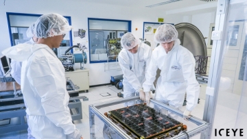
ICEYE, a global leader in continuous observation services and natural disaster solutions, has strengthened its continuous Earth observation capabilities with the successful launch of three satellites, including a new satellite equipped with a 1,200 MHz radar.
IceEye successfully launched three additional SAR (Synthetic Aperture Radar) satellites on March 4, 2024 (US West Coast Time), including a technology demonstrator with a 1,200 MHz radar bandwidth capable of capturing images with the industry's highest resolution of 25 cm.
These satellites were launched on this day from Vandenberg Space Force Base in California aboard SpaceX’s Rideshare Transporter-10 and were placed into orbit by Exolaunch, a satellite separation and integration company.
Communication with the satellites has been successfully established, and normal initial operations are underway.
Of the three SAR satellites launched for the mission, two were manufactured by Iceeye’s U.S. subsidiary, and one is an in-orbit technology demonstrator manufactured by Iceeye Finland.
This demonstrator model, equipped with an upgraded version of IceEye's unique X-band antenna, can capture high-resolution images of up to 25 cm using a 1,200 MHz radar bandwidth. IceEye is scheduled to undergo engineering testing first and then be immediately deployed into commercial service.
Rafal Modrzewski, co-founder and CEO of Iceeye, stated, “Through an expanded constellation of satellites, Iceeye provides objective and reliable information that enables a more rapid and accurate response to changes occurring anywhere on Earth. With the launch of the 1,200 MHz bandwidth technology demonstrator, we are able to capture SAR images with a resolution of 25 cm, providing customers with the highest level of clarity through detailed remote sensing, thereby offering them top-priority decision-making capabilities.”

Comments
Related news
Ice Eye Begins Full-Scale Satellite Service Customer Support
Earth observation company ICEYE, which operates the world's largest SAR (Synthetic-Aperture Radar) satellite constellation, has established a dedicated business division for satellite sales and customer satellite management, and has begun full-scale customer support operations.
2022.07.21by 강정규 기자
Iceeye Wins NASA Mission
ICEYE US has received its first task order under a BPA (Blanket Purchase Agreement) with NASA announced earlier this year.
2023.08.18by 배종인 기자
.jpg)
IceEye strengthens Earth observation data collection capabilities
ICEYE, a global leader in continuous Earth observation using radar imaging satellites and a specialist in natural disaster solutions, has strengthened its Earth observation data collection capabilities through the launch of new satellites.
2023.11.14by 배종인 기자
European Patent Applications Surpass 200,000 for the First Time… South Korea Maintains 5th Place, Led by Batteries and Telecommunications
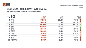
According to the European Patent Office (EPO)'s 'Technology Dashboard 2025', European patent applications last year reached 201,974, surpassing 200,000 for the first time. Korean companies and inventors filed 14,355 applications, representing a 9.5% increase from the previous year and maintaining 5th place by country. Battery, digital communication, and semiconductor technologies led the growth, with Samsung ranking as the top EPO applicant for the second consecutive year and LG reaching 3rd place. The presence of major domestic cities such as Seoul, Suwon, and Yongin was also confirmed. It was also revealed that Korea's European patent strategy is expanding beyond individual technologies to span the entire industry.
2026.03.24by 명세환 기자

SK Telecom First Applies AI-Based Network Operations at Gwanghwamun K-Pop Concert
SK Telecom announced that it applied an AI-based network operation system for the first time at a large-scale K-pop concert held in the Gwanghwamun area of Seoul on March 21st, managing communication quality throughout the event. Mobile data usage during the three hours before and after the concert reached 12.15TB, approximately doubling compared to the same time slot the previous weekend. SK Telecom monitored traffic using the AI system 'A-One' in five-minute and 50-meter units to respond to potential overload situations, while also operating temporary communication facilities and on-site personnel in parallel. This case is interpreted as confirmation of the practical applicability of AI-based autonomous network operation in an environment where demand from dense events and foreign users increases simultaneously.
2026.03.23by 명세환 기자











