



iSci, Monitors Tropical Forests Blocking Clouds... Launches SAR-Based Forest Destruction Monitoring Solution
 Published2026.03.10 10:47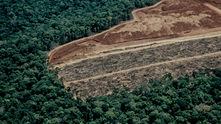
Supports detection of illegal logging and mining using Synthetic Aperture Radar (SAR) technology that complements the observation limitations of optical satellites
Satellite data company ICEYE has launched a satellite-based monitoring solution capable of more rapidly identifying deforestation in tropical forest regions. The goal is to enhance response capabilities against illegal logging and mining activities by utilizing Synthetic Aperture Radar (SAR) technology, which enables observation even in cloudy and adverse weather conditions.
iSci announced on March 10 that it has unveiled a forest destruction monitoring solution. The solution is designed to enable government agencies, enforcement organizations, and environmental protection groups to monitor forest damage in near real-time, even in areas with low visibility.
The issue of deforestation in tropical forest regions is continuously being raised by the international community. According to Global Forest Watch, approximately 28 million hectares of forest were lost in Brazil between 2000 and 2020, representing a decline of about 6%. It is reported that illegal logging and mining activities are continuing, particularly in remote areas that are difficult to access or in regions obscured by clouds.
The limitations of existing satellite observation methods are also pointed out as a problem. Optical satellites often find it difficult to acquire images for several days to weeks in tropical regions where thick cloud layers form. These observation gaps are cited as a factor that makes a rapid response difficult even if forest damage occurs.
To address these issues, i-Sci proposed a monitoring method utilizing a SAR satellite constellation. SAR imagery can collect data regardless of weather conditions or day/night cycles, and enables continuous observation even in areas with dense clouds. Furthermore, the company explains that by comparing satellite images before and after forest changes, it is possible to detect patterns of gradual forest destruction and support the securing of evidence.
Andy Reed, Head of Government Solutions at iSci, stated that rapid response is crucial in forest protection activities and that SAR-based monitoring can reduce blind spots in existing observations and provide continuous information. He predicted that these capabilities could bring about a change in the way forest protection authorities and environmental organizations respond.
Environmental research institutions are also emphasizing the need for continuous monitoring. Dr. Lillian Pintea, Vice President of Conservation Science at the Jane Goodall Institute, explained that a stable observation system is crucial given the increasing illicit mining and deforestation in remote areas. Analysis suggests that access to cloud-passing satellite data will help to more clearly assess the extent of forest damage and set response priorities.
I-Sci has been observing forest changes in Brazil for a long period and, based on this, has developed a monitoring service with enhanced environmental information analysis capabilities. This service can be utilized to support the activities of environmental protection NGOs, ensure transparency in the management of donations, and facilitate national-level climate change reporting and compliance with environmental regulations.
As tropical forest conservation emerges as a major challenge in international environmental policy, satellite-based monitoring technology is considered a key tool for supporting forest protection policies. Icy announced that it plans to support the establishment of long-term conservation strategies for major forest ecosystems, such as the Amazon and Congo Basin, by combining continuous satellite observation and data analysis.

Comments
Related news
Ice Eye Begins Full-Scale Satellite Service Customer Support
Earth observation company ICEYE, which operates the world's largest SAR (Synthetic-Aperture Radar) satellite constellation, has established a dedicated business division for satellite sales and customer satellite management, and has begun full-scale customer support operations.
2022.07.21by 강정규 기자
Iceeye Wins NASA Mission
ICEYE US has received its first task order under a BPA (Blanket Purchase Agreement) with NASA announced earlier this year.
2023.08.18by 배종인 기자
.jpg)
IceEye strengthens Earth observation data collection capabilities
ICEYE, a global leader in continuous Earth observation using radar imaging satellites and a specialist in natural disaster solutions, has strengthened its Earth observation data collection capabilities through the launch of new satellites.
2023.11.14by 배종인 기자
.jpg)
IceEye Launches 25cm Ultra-High Resolution Advanced Radar Satellite
ICEYE, a global leader in continuous observation services and natural disaster solutions, has successfully launched three additional Synthetic Aperture Radar (SAR) satellites, including a technology demonstrator featuring 1,200MHz radar bandwidth capable of capturing imagery at 25cm resolution, the industry's highest.
2024.03.07by 배종인 기자
.jpg)
IceEye, Successful Launch of 4 New Satellites into Orbit
ICEYE, a global leader in continuous Earth observation monitoring and natural disaster solutions through SAR (Synthetic-Aperture Radar) constellation satellite operations, successfully launched four new satellites on August 17, 2024 (Korea Standard Time), further expanding the scale of the world's largest SAR constellation satellite that it already operates.
2024.08.21by 배종인 기자











