


Get the 'Precision Road Map' needed for developing self-driving cars
 Published2016.02.29 17:39
A high-precision road map created to open the era of autonomous vehicles will be provided free of charge starting on the 29th.
The high-precision road map includes an electronic map (including 3D coordinates) produced with an accuracy of 25 cm that includes lanes (regulation lines, road boundaries, stop lines, and center lines), road facilities (median strips, tunnels, bridges, and underpasses), and sign facilities (traffic safety signs, road markings, and traffic signals) necessary for autonomous driving.
This is part of the follow-up measures to support the commercialization of autonomous vehicles announced at the 3rd Regulatory Reform Ministerial Meeting in May 2015.
The goal is to actively support not only automobile manufacturers but also academia and research institutes to conduct active research and development by distributing high-precision road maps free of charge, thereby contributing to the realization of the goal of commercializing autonomous vehicles by 2020.
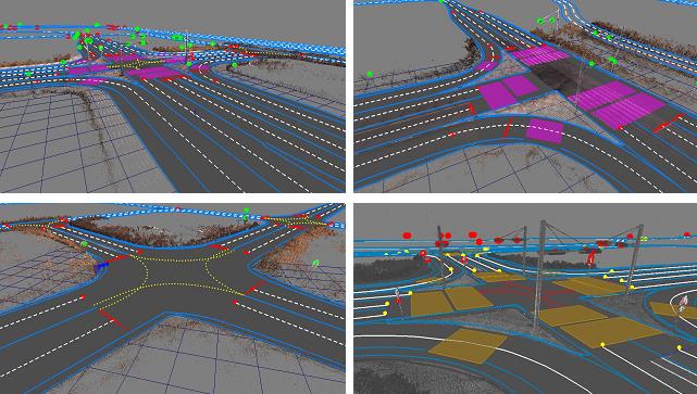
▲Precision road map sample image (intersection)
As seen in the case of Google leading the research and development of self-driving cars based on maps and the recent acquisition of Nokia's map service 'Here' by three German automakers including BMW, high-precision maps are essential elements for self-driving cars along with various sensors such as global navigation satellite systems (GNSS) and cameras.
Until now, automobile manufacturers, research institutes, and venture companies had to create high-precision maps themselves to research and develop autonomous vehicles, but there were many difficulties due to limitations in budget and technological capabilities.
Accordingly, the National Geographic Information Institute of the Ministry of Land, Infrastructure and Transport conducted a “Research on the Construction of a Precision Road Map to Support Autonomous Vehicles” project last year to establish efficient construction methods, technical criteria, and standards for precision road maps, and produced an accurate and standardized precision road map for the test operation section.
In addition, in order to collect opinions on the application of precision road maps, a cooperation meeting was held with related organizations including the Ministry of Land, Infrastructure and Transport, automobile manufacturers, the Korea Automobile Industry Association, and the Korea Automobile Safety Research Institute on the 28th of last month, and there are plans to make this a regular event in the future.
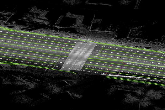 <br /> ▲Precision road map sample image (straight line section)
The scope of this disclosure is one section of the highway (42km) among the test operation sections, three sections of general national roads (186km), and the advanced driving test track (13km) of the Korea Transportation Safety Authority Automobile Safety Research Institute. The two sections of general roads that have not yet been built are planned to be manufactured and provided in the first half of this year.
The test operation section is one section of the expressway (Gyeongbu Expressway Seoul Tollgate-Singal Junction, Yeongdong Expressway Singal Junction-Hobop Junction, 42 km) and five sections of national highways (Suwon, Hwaseong, Yongin, Goyang, etc., 320 km).
The high-precision road map can be obtained by visiting the National Geographic Information Institute directly from February 29. The National Geographic Information Institute announced that it plans to produce a high-precision road map optimized for autonomous vehicles by collecting user opinions, such as applicability evaluations, along with providing the high-precision road map.
Comments
Related news
Will domestic production of image processing processors secure competitiveness in autonomous vehicles?
The Aldebaran processor is a purely domestic Korean CPU that does not use ARM cores and is capable of supporting high-resolution video processing, offering bright prospects for the realization of autonomous vehicles in the future. The new Aldebaran processor, AB-TS3, is equipped with a quad-core capable of 4K video processing, an H.265 (HEVC) encoder, and VD/PD/LD engines.
2015.10.12by 신윤오 기자

Where Are We in Core Sensor Element Development? ② “Development of 79GHz Automotive Radar Sensor to Preempt the Autonomous Vehicle Market”
Following last week's updates on smart motion sensors, metabolic rate measurement sensors, harmful gas sensors, and optical sensors, we introduce the following technologies: ▲automotive shunt resistance current sensors ▲lidar sensors for autonomous vehicles ▲automotive 79GHz radar sensor technology.
2015.11.23by 신윤오 기자
Domestic push for autonomous vehicles on actual roads is in its infancy, while overseas markets are racing to fully apply artificial intelligence.
As the government has decided to implement autonomous vehicle road tests, attention is once again focusing on core autonomous driving technologies. The Ministry of Land, Infrastructure and Transport (Minister Kang Ho-in) announced its '2016 Business Plan' on the 28th of last month, selecting autonomous vehicle industry development as one of the seven new industries in land, infrastructure and transport. This development plan includes technology development support projects such as real-road testing of autonomous vehicles, designation of pilot operation zones, and construction of experimental cities.
2016.02.01by 신윤오 기자

[e4ds Tech Day 2026 ⑨] Sim Sang-gyu, Autocrypt CTO: "In the Physical AI Era, Automotive Security Must Extend Beyond the Vehicle"
At e4ds Tech Day 2026, Sim Sang-gyu, CTO of Autocrypt, explained automotive cybersecurity strategies in the era of Physical AI and SDV (Software-Defined Vehicle). Automobiles are evolving as part of an ecosystem connected to AI, cloud, chargers, IoT, and robots, and he emphasized that the scope of security must expand beyond the vehicle interior to the entire connected environment. In particular, AI model tampering, adversarial attacks, OTA updates, and EV charger hacking were identified as major threats. He explained that response measures require zero trust, AI model integrity protection, intrusion detection, Security by Design and Default, and full lifecycle security management, and that proactive security system establishment beyond regulatory compliance is critical for securing future mobility competitiveness.
2026.10.12by 배종인 기자

Practical HIL Construction Strategy for Automotive and Off-Highway Controller Validation
As vehicle E/E architecture transitions to zonal structures and shifts to software-defined vehicles (SDV), the number of controllers (ECUs) requiring validation and software complexity are surging dramatically. Meanwhile, real vehicle testing cannot provide repeated verification under identical conditions and entails lead time and safety concerns. This white paper explains the principles of HIL (Hardware-in-the-Loop) validation and the structure of the NI platform composed of PXI, SLSC, and VeriStand, and through two actual implementation cases—Camera Record & Replay HIL for In-Cabin Monitoring Controller (ICMU) and Forklift Controller (VCU) HILS—describes how controller-level regression testing becomes possible. Additionally, it explicitly states application boundaries and limitations, such as lack of A2B support.
2026.10.12by 편집부











